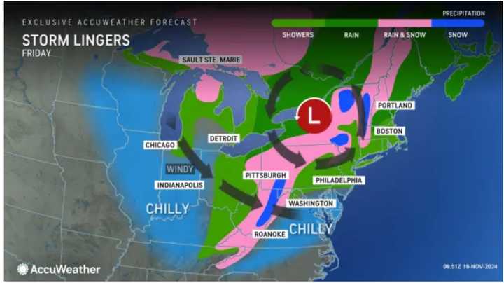
The time frame for the system is from late Wednesday night, Nov. 20, through Friday, Nov. 22.
It will bring the first soaking rain to much of the Northeast since late September. There will also be areas of snow in some spots farthest inland on the back end of the system, especially in western New York.
Some places will see up to 2 inches of much-needed rainfall, while in areas shown in the first image above from AccuWeather.com, up to a foot or more of snowfall could fall.
"There is the potential for a foot or more of snow to fall over the ridges, plateaus, and peaks in the mountains of West Virginia, western Maryland, and western Pennsylvania from the setup later this week and into this weekend," said AccuWeather Senior Meteorologist Dan Pydynowski. "It is possible that elevations near and above 2,000 feet can easily end up with a foot or more of snow."
It will become overcast Tuesday night, Nov. 19, leading to cloudy skies throughout Wednesday. The high temperature will be in the upper 50s.
The storm will arrive from west to east starting around 10 p.m. Wednesday.
It will bring rainfall through the overnight and wind speeds of around 10 miles per hour with gusts up to 30 mph. About three-quarters of an inch of rain is expected overnight.
There will be rain throughout the day on Thursday, Nov. 21. It will be a raw day with a high temperature of around 50 degrees. It will remain blustery with wind gusts between 25 and 30 mph.
Generally, another half-inch to an inch of rain is expected during the day on Thursday.
There will be more periods of rain on Friday, which will be cooler, with a high temperature in the low 40s.
As the system pushes out and the temperature drops into the 30s, there will be more widespread spotty snowfall, especially in the Northeast and those areas above farther south and west expected to see accumulating snow.
The outlook for Saturday, Nov. 23, calls for mostly cloudy skies and temperatures topping out in the mid-40s. There is a slight chain of light rain during the day, but skies will gradually begin to clear at night.
Check back to Daily Voice for updates.
Click here to follow Daily Voice Upton-Mendon and receive free news updates.

