


Original forecast models had the system arriving in the region during the day on Friday, Jan. 19, but the latest outlook predicts the system will begin moving from the south to the Northeast overnight Thursday, Jan. 18 into Friday morning. (See the first image above from AccuWeather.com.)
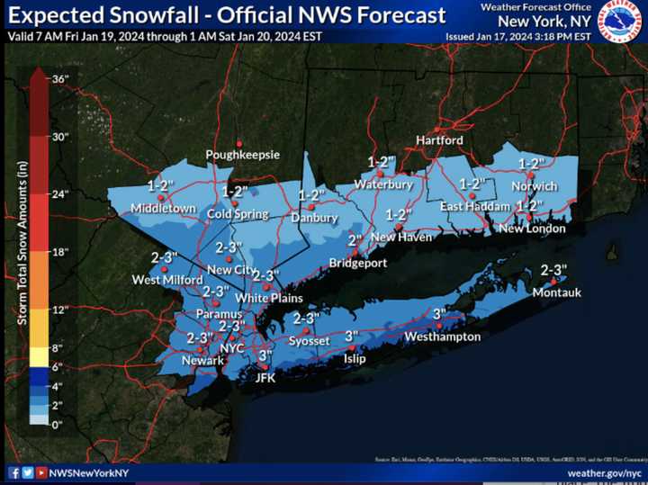
A widespread 1 to 3 inches of snowfall is expected in areas shown in sky blue in the second image age above from AccuWeather.com. Locally higher amounts are possible in some spots.
Areas in western New York and northwestern Pennsylvania (shown in Columbia blue) could see a half-foot of accumulation.
Parts of southern Pennsylvania and West Virginia (shown in the darkest shade of blue) could see a foot of accumulation.
There's still some uncertainty regarding the projected track, timing, and strength of the system.
Wednesday, Jan. 17 will be sunny and cold, with a high temperature only in the mid-20s, and wind-chill values in the single digits and teens, the National Weather Service says.
Clouds will return on Thursday, Jan. 18 with a high temperature of around 30 degrees and wind-chill values in the teens.
The system will arrive with snow showers overnight into Friday morning, with snow becoming likely after daybreak.
Friday's high temperature will be around 30 degrees.
Friday's storm system is now expected to wind down late Friday afternoon, but lingering snow showers are possible Friday night.
The weekend will be dry and cold with partly sunny skies Saturday, Jan. 20, and sunny skies on Sunday, Jan. 21. Saturday's high temperature will be in the low 20s, and Sunday's high in the upper 20s to around 30 degrees.
Check back to Daily Voice for updates.
Click here to follow Daily Voice New Haven and receive free news updates.