-

by
Ben Crnic
Breaking News
Flooding has forced the closure of a stretch of Route 59 near the Palisades Center in Rockland County. The closure was announced at around 1:43 p.m. on Monday, Aug. 3, by the Clarkstown Police Department.According to police, all eastbound lanes of Route 59 are closed in the area of the Palisades Center at Cemetery Lane because of flooding. Drivers should avoid the area and seek ...
-

by
Cecilia Levine
Weather
New Jersey is officially on storm alert with all 21 counties under a winter storm watch ahead of a system.The National Weather Service offices in Mount Holly and New York issued winter storm watches Friday afternoon, Feb. 20, covering every county in New Jersey from Sunday morning through Monday afternoon.Forecasters say heavy snow is possible statewide. Snow totals could exceed 6 ...
-
by
Cecilia Levine
Weather
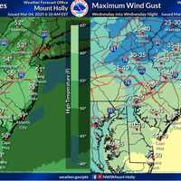
A strong storm system will sweep across New Jersey and Pennsylvania on Wednesday, March 5, delivering damaging winds, torrential rain, and possible severe thunderstorms, according to the National Weather Service (NWS) Mount Holly.Wind gusts between 45 and 50 mph are expected across much of the region, with higher gusts nearing 60 mph possible along the Jersey Shore and Delmarva ...
-

by
Joe Lombardi
National Interest
Brand-new snowfall projections have been released for a major winter storm that is heading toward the East Coast.Click here for a new, updated story - Here's Timing, Latest Snowfall Predictions For Major New Winter StormIt's expected to arrive in the Northeast late Wednesday afternoon, Feb. 19, moving up from the south before winding down around midday on Thursday, Feb. 20, according to ...
-

by
Jillian Pikora
Your Community
A powerful winter storm is set to bring hazardous travel conditions across Pennsylvania, prompting several school delays and closings, officials say.As of 10:00 p.m. Wednesday, Feb. 5, the following schools across the state announced closures or delays:ADAMS COUNTY (Closed):Bermudian Springs School DistrictConewago Valley School DistrictFairfield Area School DistrictGettysburg Area ...
-
by
Cecilia Levine
Your Community
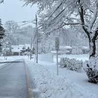
A wintry mix will bring hazardous travel conditions across the region beginning late Wednesday night into Thursday morning, Feb. 6, prompting several school delays and closings, officials say.The following schools in North Jersey announced delayed openings or closures:BERGEN (closed):AllendaleBergen County Special ServicesBergen County ...
-

by
Cecilia Levine
Weather
It’s not exactly a snowpocalypse, but a winter storm is making its way to the DMV on Friday, Jan. 3, bringing a light dusting, colder temps, and potentially hazardous travel conditions.While snow lovers may be disappointed with predictions of just 1 to 2 inches for most of the area, the National Weather Service is warning that bursts of snow could create slushy roads and tricky commutes ...
-
by
Cecilia Levine
Weather
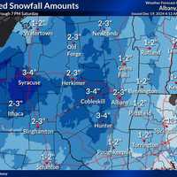
A winter storm is poised to bring light to moderate snowfall to eastern New York, western Massachusetts, and parts of Connecticut from Friday morning, Dec. 20 through Saturday evening, Dec. 21, according to the National Weather Service.A Hazardous Weather Outlook has been issued for the region, warning of slippery travel conditions, particularly during the Friday evening commute. While ...
-
by
Cecilia Levine
Weather
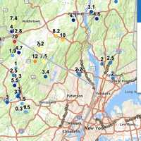
Snowfall totals in New Jersey and Pennsylvania have surged higher than earlier reports, with some areas now measuring up to 20 inches, the National Weather Service announced Friday, Nov. 22.High Point, NJ, has officially recorded 20 inches of snow as of Friday morning, marking the highest total in the region. In Pennsylvania, Richmondale follows closely with 19.5 inches, and Cortez ...
-

by
Merriell Moyer
Your Community
JD Vance, former President Donald Trump's running mate in the 2024 election, is holding a campaign rally in Bucks County, and there could be some traffic disruptions, according to Pennsylvania State Police.Vance will be at the Newtown Sports and Events Center, 207 Penns Trail, Newtown at 8:30 p.m. on Monday, Nov. 4, according to the Trump campaign website. Doors open at 6:30 p.m.Traffic ...
-

by
Ben Crnic
Breaking News
Ahead of an upcoming storm system expected to last several nights, New York Gov. Kathy Hochul is urging residents across the state to prepare for snow, heavy rains, power outages, and flooding. According to the latest predictions, the storm is expected to arrive in the Hudson Valley, Capital Region, and Long Island on Tuesday, April 2, and continue through Thursday night, April 4, ...
-

by
Joe Lombardi
Weather
A new winter storm could bring a mix of snow, sleet, and rain that could cause slippery travel conditions in parts of the region.The time frame for the system is late Monday night, March 6 into Tuesday morning, March 7, according to the National Weather Service.But its projected track is uncertain.One forecast model is taking it a bit farther west. (See the image above from ...
-
by
Joe Lombardi
Weather
The most potent winter storm of the season has resulted in scores of school closures and slippery travel conditions.Here's a look at some snowfall totals reported to the National Weather Service and other sources on Tuesday morning, Feb. 28.If you don't see your town listed, post the total in a comment.New YorkManhattanCentral Park, 1.8 inchesNassau CountyManhasset Hills, 3.5 ...
-

by
David Cifarelli
Weather
Thousands of Massachusetts residents were in the dark as a wintry storm system dumping both rain and snow moved through the area on Monday, Jan. 23.A Winter Weather Advisory was in place for about half of the state while a Winter Storm Warning was in place for the other half until 5 p.m, the National Weather Service reports. Snowfall totals, some up to five inches, were expected to be ...
-

by
Joe Lombardi
Weather
Damaging wind gusts of 50 miles per hour will be the main threat in this region for a potent pre-Christmas storm accompanied by a cold front that will sweep through the Northeast and result in a dramatic drop in temperatures.The time frame for the storm is a period of approximately 24 hours from Thursday, Dec. 22 to Friday, Dec. 23.Heavy downpours could also lead to poor travel ...
-
by
Joe Lombardi
Weather
Damaging wind gusts of 50 miles per hour will be the main threat in this region for a potent pre-Christmas storm accompanied by a cold front that will sweep through the Northeast and result in a dramatic drop in temperatures.The time frame for the storm is a period of approximately 24 hours from Thursday, Dec. 22 to Friday, Dec. 23.Heavy downpours could also lead to poor travel ...
-

by
Joe Lombardi
Weather
The first projected snowfall totals have been released for a potent pre-Christmas storm that will bring snow, rain, and strong winds that could cause poor travel conditions and power outages.The system is due to arrive on Thursday, Dec. 22, and continue into Friday, Dec. 23, the National Weather Service said.Current models show the chance for potentially significant snowfall in some ...
-

by
Joe Lombardi
Weather
A storm system packed with a wide swath of snow, rain, and strong winds is expected to cause poor travel conditions and bring accumulating snowfall to some spots in the days leading up to Christmas.The system is due to arrive on Thursday, Dec. 22, the National Weather Service said.Areas expected to see accumulating snowfall Thursday and Friday, Dec. 23 are shown in blue in the first ...
-

by
Joe Lombardi
Weather
A potentially historic, extreme storm that will bring intense snowfall and accumulation of 3 to 6 feet to parts of New York over a period of days has prompted Gov. Kathy Hochul to issue a State of Emergency for 11 counties in the state.The most significant snowfall is expected Thursday, Nov. 17, and Friday, Nov. 18, with accumulations of up to 3 feet of snow possible in the Buffalo ...
-

by
Cecilia Levine
Weather
Snow was coming down by noon all across the Northeast Saturday morning, postponing St. Patrick's Day parades and making for messy travel conditions.While only about an inch or two had fallen in the suburbs of New York City and Washington DC, the worst of the storm was yet to come for some areas.Here's how much snow is expected to have accumulated across PA and NJ area by 7 p.m. ...
-

by
Joe Lombardi
Weather
The arrival of a cold front will bring strong wind gusts that could be accompanied by snow squalls that could cause whiteout conditions on Sunday, Feb. 27, according to the National Weather Service. Sunday will start off sunny with a high temperature in the low 40s, but wind-chill values between 15 and 25 degrees thanks to wind speeds in the teens and gusts as high as 25 miles per hour. ...
-
by
Joe Lombardi
Weather
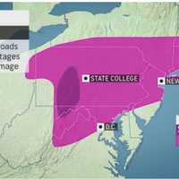
The arrival of a massive winter storm bringing a mix of snow, sleet and freezing rain has caused hazardous travel conditions and many school closures throughout the region on Friday, Feb. 25.The wide area where icy conditions are causing slippery travel conditions are shown in the first image above.A look at the types of precipitation by area on Friday, Feb. 25 are shown in the second ...
-

by
Joe Lombardi
Weather
A new storm system bringing a mix of sleet, freezing rain, and snow is causing slippery travel conditions in some spots in the region.The system arrived just before daybreak on Monday, Feb. 7 and is expected to wind down by around noontime when the temperature will rise above the freezing mark throughout the area.There will be sleet and snow showers during the morning commute and ...
-

by
Nicole Valinote
Breaking News
New York State agencies have prepared emergency response assets ahead of a winter storm that could bring more than a foot of snow to parts of the state.The storm could bring heavy snow to parts of Long Island, New York City, and the Hudson Valley regions beginning in the evening of Friday, Jan. 28, according to an announcement from Gov. Kathy Hochul.Some areas could see between 6 and 12 ...
-

by
Joe Lombardi
Weather
A storm system bringing a mix of sleet and snow to the region is causing slick travel conditions and closures and delayed starts at many school districts.The quick-moving system started out as rain overnight Thursday morning, Jan. 20 before changing to sleet and snow just before daybreak as the temperature fell to around the freezing mark, prompting the National Weather Service to issue ...
-
by
Joe Lombardi
Weather
A new storm system expected to bring accumulating snowfall and cause slick travel conditions will be followed by the potential for a major Nor'easter during an active weather pattern in the region.The quick-moving system should bring widespread snowfall overnight Wednesday into daybreak on Thursday morning, Jan. 20. (See the first image above.) Generally, an inch or so of accumulation ...
-

by
Joe Lombardi
Weather
A new storm sweep that will sweep through the region won't bring more snowfall but will be accompanied by freezing rain and sleet that could lead to dangerous travel conditions.The time frame for the storm is Sunday, Jan. 9, from about daybreak to 11 a.m.Total ice accumulations of a light glaze is possible, the National Weather Service said in a Hazardous Weather Outlook statement ...
-

by
Cecilia Levine
Weather
Up to a foot of snow was possible Monday in South Jersey, with blizzard conditions likely to last until the afternoon.Only a light dusting to an inch was expected in the northern part of the state.A State of Emergency was declared in Atlantic, Burlington, Cape May, Cumberland and Ocean counties by Gov. Phil Murphy Sunday night.Meanwhile, the National Weather Service expanded a winter ...
-

by
Joe Lombardi
Weather
Separate quick-moving systems will bring multiple wintry weather events across the region through Christmas.The first system has the potential for a light coating of snowfall, less than an inch, Thursday night, Dec. 23 into Friday morning, Dec. 24 for most of the region, with the potential for more snowfall farther north in New York and New England, according to the National Weather ...
-

by
Joe Lombardi
Weather
It's been an endless winter, and it's not over yet.For starters, the slow-moving late-week storm system that arrived on Thursday, Feb. 18 delivered a parting shot to parts of the region with a surprising new round of light snow on Saturday morning, Feb. 20, causing slippery travel conditions.Skies will clear though, leading to a mostly sunny day on Saturday, Feb. 20 with a high ...
-

by
Cecilia Levine
Weather
The most impactful part of the winter storm slamming the Northeast was expected Monday afternoon, with gusty winds and up to two feet of snow on the way.Between 3 and 6 inches of snow had already fallen as of 11 a.m. in parts of Eastern PA and North/Central Jersey, the National Weather Service reports.The sleet and freezing rain falling in some areas will soo change back to snow, a ...


