Tag: Storm Prediction Center
Tornado, Flood, Hail Threat As ‘Extreme Thunderstorms’ Slam Maryland, Virginia
Wild winds, large hail, floods, and possible tornadoes may roll through the region overnight, forecasters are warning.
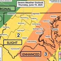
The National Weather Service issued a "Level 3 High Impact Severe Weather Threat" on Thursday, June 19, as storms begin hitting the area.
12:24pm CDT #SPC_MD 1364 , #njwx #pawx #dewx #mdwx #vawx #dcwx #wvwx, https://t.co/Y7ej7h7rco pic.twitter.com/q6cAaizrQk — NWS Storm Prediction Center (@NWSSPC) June 19, 2025
Officials also issued severe thunderstorm and flood warnings for parts of Virginia and western Maryland.
"Severe Thunderstorm Watch in effect for a large porti…
Tornado Risk, 70 MPH Winds, 100° Heat: NJ Braces for Explosive Weather Outbreak (Timing)
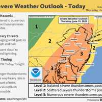
New Jersey is facing a one-two weather punch Thursday, June 19 (Juneteenth): dangerous heat and the threat of severe storms, the National Weather Service warns.
High temperatures in the low 90s, paired with tropical humidity, could push the heat index to 100 degrees across much of the state, especially south of I-78, according to the Mount Holly Forecast Office. Conditions are expected to peak Thursday, June 19, between 4 p.m. and 10 p.m.
"High temperatures in the low 90s combined with high humidity will lead to heat indices reaching 95–100 degrees," forecasters said in the latest alert. "D…
Severe Thunderstorm Watch In Effect For 10 NJ Counties, NWS Warns
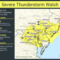
A Severe Thunderstorm Watch is in effect for 10 New Jersey counties through 7 p.m. Wednesday, June 18, as damaging storms threaten to slam the region with hail, wind, and lightning, according to the National Weather Service.
The counties under watch include:
Atlantic, Burlington, Camden, Cape May, Cumberland, Gloucester, Mercer, Monmouth, Ocean, and Salem.
The Storm Prediction Center says conditions are right for frequent lightning, heavy downpours, and wind gusts strong enough to cause property damage and power outages.
Meanwhile, residents in northeast New Jersey—including Passaic, Berg…
Severe Weather Threat Upgraded For Region: Here's Time Frame For Approaching Thunderstorms
The threat of severe weather from an approaching round of thunderstorms has just been upgraded for most of the region.
Storm activity is expected from west to east from 6 p.m. to 11 p.m. Saturday, April 1.
The area covers New York City, Long Island, Westchester, Rockland, Putnam, and Orange counties, and Fairfield, New Haven, Middlesex, and New London counties in Connecticut. (See the image above.)
"The Storm Prediction Center has placed the area in an enhanced risk of severe thunderstorms this evening," the National Weather Service said in a statement issued mid-Saturday afternoon. "…