Not Over Yet: Here's How Much Longer Stormy Conditions From Ophelia Will Last Not Over Yet: Here's How Much Longer Stormy Conditions From Ophelia Will Last Not Over Yet: Here's How Much Longer Stormy Conditions From Ophelia Will Last
Not Over Yet: Here's How Much Longer Stormy Conditions From Ophelia Will Last Post-Tropical Storm Ophelia will continue to affect much of the region with rain, heavy at times, and dangerous coastal conditions on Monday, Sept. 25, National Weather Service. "Through Monday, Ophelia will slow track back offshore off the mid-Atlantic states, prolonging the duration of wet weather and gusty winds," according to AccuWeather.com. "Although Ophelia will continue to lose wind intensity through the early week, gusty winds and drenching rain can continue to impact many communities near the coast from the mid-Atlantic into southern New England." For a radar image of the reg…
New Update: Tropical System Expected To Become Major Hurricane New Update: Tropical System Expected To Become Major Hurricane New Update: Tropical System Expected To Become Major Hurricane
New Update: Tropical System Expected To Become Major Hurricane Conditions are rapidly improving in New England as Lee, once a Category 5 hurricane, is churning into Canada as a post-tropical cyclone. Click here for a new, updated story: Newly Named Tropical Storm Nigel Forms In Busy Atlantic Now, attention has turned to what is expected to be the next major hurricane of the 2023 Atlantic season. As of 5 p.m. Saturday, Sept. 16, Tropical Depression 15 is moving north-northwest at 16 miles per hour over the open Atlantic toward the Caribbean Sea. It has maximum sustained winds of 35 miles per hour, according to a brand-new update from the …
New Tropical System Expected To Become Hurricane Forms In Atlantic New Tropical System Expected To Become Hurricane Forms In Atlantic New Tropical System Expected To Become Hurricane Forms In Atlantic
New Tropical System Expected To Become Hurricane Forms In Atlantic As Hurricane Lee makes its way northward up the coast, a new tropical system has formed. Click here for a new, updated story: Newly Named Tropical Storm Nigel Forms In Busy Atlantic As of late Friday morning, Sept. 15, Tropical Depression 15 is moving northwest at 15 miles per hour over the open Atlantic toward the Caribbean Sea.  It's expected to become a hurricane northeast of the Lesser Antilles, according to the National Hurricane Center. Its highest sustained winds are estimated to be 35 miles per hour, the National Hurricane Center said. If it becomes a tropical s…
Hurricane Lee Set To Batter Northeast Coast With Damaging Winds, Heavy Rain: Here's Timing Hurricane Lee Set To Batter Northeast Coast With Damaging Winds, Heavy Rain: Here's Timing Hurricane Lee Set To Batter Northeast Coast With Damaging Winds, Heavy Rain: Here's Timing
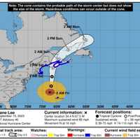
Hurricane Lee Set To Batter Northeast Coast With Damaging Winds, Heavy Rain: Here's Timing Hurricane Lee is now just hours away from unleashing damaging winds likely to cause scores of power outages along with drenching downpours in New England while coastal flooding and dangerous rip currents are expected in coastal New York and Connecticut. Updated story - New Tropical System Expected To Become Hurricane  The timing for Lee's effects is from Friday night, Sept. 15 into Saturday evening, Sept. 16. Tropical storm warnings and other advisories extend up the East Coast from Long Island to easternmost Maine. The newest computer models show Lee's expected landfall to be from…
Latest On Lee: These Mass Areas Most At Risk For Power Outages, Storm Surge Latest On Lee: These Mass Areas Most At Risk For Power Outages, Storm Surge Latest On Lee: These Mass Areas Most At Risk For Power Outages, Storm Surge
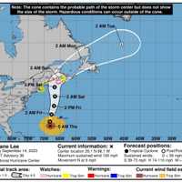
Latest On Lee: These Mass Areas Most At Risk For Power Outages, Storm Surge With Hurricane Lee barreling on a path toward the Northeast, meteorologists have now identified the areas of Massachusetts that may face the most devastation and power outages from storm surges and damaging winds.  According to the latest information from the National Weather Service, the storm is expected to arrive in southern New England on Friday night, Sept. 15, and stay through Saturday evening, Sept. 16.  Earlier Report - Here Comes Hurricane Lee: Watches, Advisories Stretch From NY Through New England As of early Thursday morning, Sept. 14, the storm was around 830 mi…
Here Comes Hurricane Lee: Watches, Advisories Stretch From NY Through New England Here Comes Hurricane Lee: Watches, Advisories Stretch From NY Through New England Here Comes Hurricane Lee: Watches, Advisories Stretch From NY Through New England
Here Comes Hurricane Lee: Watches, Advisories Stretch From NY Through New England Watches and advisories now stretch from New York through New England as millions are expected to be affected by damaging winds and heavy rain from Hurricane Lee. Click here for a new, updated story - Hurricane Lee Set To Batter Northeast Coast With Damaging Winds, Heavy Rain: Here's Timing The newest computer models have the track of the massive system veering back a bit farthest east after models a day earlier projected landfall in coastal Maine. Now, its eye is expected to pass over land near the easternmost tip of Maine and Nova Scotia on Monday,  Sept. 18, near Halifax. As …
Threat Grows For Hurricane Lee To Be Rare Significant Storm To Hit Mass Threat Grows For Hurricane Lee To Be Rare Significant Storm To Hit Mass Threat Grows For Hurricane Lee To Be Rare Significant Storm To Hit Mass
Threat Grows For Hurricane Lee To Be Rare Significant Storm To Hit Mass As meteorologists predict a possible New England landfall for Hurricane Lee, the prospect is bringing memories of other past storms that slammed into Massachusetts throughout the 20th century.  According to the latest computer models from the National Weather Service, Hurricane Lee may make landfall in eastern Maine on Monday morning, Sept. 18, bringing powerful winds, heavy rains, and high surf along with it and possibly devastating parts of Eastern Massachusetts. Click here for the latest update - Here Comes Hurricane Lee: Watches, Advisories Stretch From NY Through New England While it…
Hurricane Lee Won't Have Much Impact On Region, Weather Maps Show Hurricane Lee Won't Have Much Impact On Region, Weather Maps Show Hurricane Lee Won't Have Much Impact On Region, Weather Maps Show
Hurricane Lee Won't Have Much Impact On Region, Weather Maps Show Hurricane Lee is expected to make landfall in Canada sometime over the weekend. What does that mean for New Jersey, Pennsylvania, and the mid-Atlantic states? Not a lot. ...TROPICAL STORM CONDITIONS EXPECTED ON BERMUDA BEGINNING EARLY TOMORROW... ...RISK OF WIND, COASTAL FLOODING, AND... Posted by NOAA NWS National Hurricane Center on Wednesday, September 13, 2023 Lee's most-likely course shows it will make landfall in Atlantic Canada at the end of the week, and its most significant impacts will be felt in Halifax and some of New England. In New Jersey, Pennsylvania, and the mid-Atla…
Hurricane Lee Track Shifts: Threat To Northeast Grows, Chance Of New England Landfall Increases Hurricane Lee Track Shifts: Threat To Northeast Grows, Chance Of New England Landfall Increases Hurricane Lee Track Shifts: Threat To Northeast Grows, Chance Of New England Landfall Increases
Hurricane Lee Track Shifts: Threat To Northeast Grows, Chance Of New England Landfall Increases A slight north-northwest shift in the projected track of Hurricane Lee poses an increased threat for the Northeast with landfall now possible in New England. Click here for the latest update - Here Comes Hurricane Lee: Watches, Advisories Stretch From NY Through New England The newest computer models show possible landfall in eastern Maine early Monday morning, Sept. 18. Previous models had the likely landfall being in Nova Scotia, near Halifax. The effects of Lee will be felt for the first time in much of the East Coast beginning later in the day Wednesday morning, Sept. 13 wh…
Hurricane Lee Growing Larger Before Expected Northward Turn: Latest Projected Landfall Timing Hurricane Lee Growing Larger Before Expected Northward Turn: Latest Projected Landfall Timing Hurricane Lee Growing Larger Before Expected Northward Turn: Latest Projected Landfall Timing
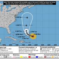
Hurricane Lee Growing Larger Before Expected Northward Turn: Latest Projected Landfall Timing Hurricane Lee is growing in size before it is expected to take a sharp northerly turn by midweek. Click here for a new, updated story: Hurricane Lee Track Shift Poses Increased Threat For Northeast, Possible New England Landfall As of around 11 a.m. Tuesday, Sept. 12, Lee is located about 550 miles south of Bermuda with 115 mile-per-hour winds. A Category 3 storm on the Saffir-Simpson Hurricane Wind Scale, it's moving northwest at 6 miles per hour, the National Hurricane Center said. Hurricane-force winds now extend 90 miles from Lee’s center, an increase from the weekend. Some slowing…
Hurricane Lee Restrengthens: New Models Predict Timing, Expected Site Of Landfall Hurricane Lee Restrengthens: New Models Predict Timing, Expected Site Of Landfall Hurricane Lee Restrengthens: New Models Predict Timing, Expected Site Of Landfall
Hurricane Lee Restrengthens: New Models Predict Timing, Expected Site Of Landfall Hurricane Lee has restrengthened as it is just days away from affecting a massive stretch of coastline along the East Coast. Click here for the latest update - Here Comes Hurricane Lee: Watches, Advisories Stretch From NY Through New England As of early Monday morning, Sept. 11, Lee is located 340 miles north of the Leeward Islands in the Caribbean with 120 mile-per-hour winds. Now a Category 3 storm, it's moving northwest at 7 miles per hour, the National Hurricane Center said. It could briefly return to Category 4 status Tuesday morning, Sept. 12 before returning to Category 2 sta…
Hurricane Lee's Risk To East Coast Rises: New Week-Long Projected Track Hurricane Lee's Risk To East Coast Rises: New Week-Long Projected Track Hurricane Lee's Risk To East Coast Rises: New Week-Long Projected Track
Hurricane Lee's Risk To East Coast Rises: New Week-Long Projected Track A new week-long projected track for Monster Hurricane Lee has been released as forecasters are now saying its risk to the East Coast has increased. "Hurricane Lee will remain a powerful storm after undergoing rapid intensification," according to a report by AccuWeather.com on Saturday, Sept. 8. "As Lee turns northward next week dangerous surf will develop along the East Coast while the risk for direct impact rises in New England." For a look at Lee's projected path through Saturday, Sept. 16, see the image above. Lee is now a Category 3 hurricane packed with maximum sustained winds of…