Tag:

High humidity

Flood Watch, Heat Advisory Issued For NJ As State Recovers From Deadly Storms Flood Watch, Heat Advisory Issued For NJ As State Recovers From Deadly Storms
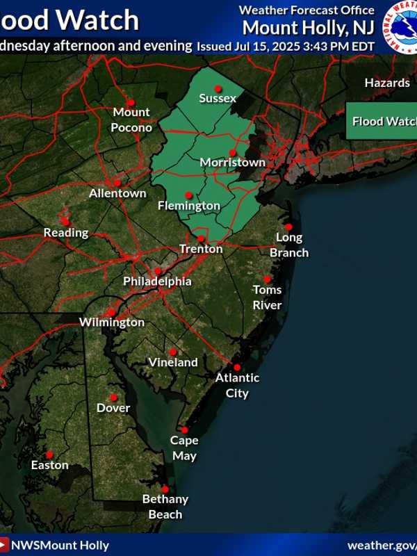
Flood Watch, Heat Advisory Issued For NJ As State Recovers From Deadly Storms Just one day after a fast-moving storm swept through New Jersey, causing dramatic rescues, a home explosion, and multiple deaths, officials have issued both a Flood Watch and Heat Advisory for the region. The Flood Watch, issued by the National Weather Service in Mount Holly, warns that flash flooding is possible in seven New Jersey counties from Wednesday afternoon, July 16, through late Wednesday night. The counties include Sussex, Warren, Morris, Hunterdon, Somerset, Middlesex, and Mercer, affecting cities such as New Brunswick, Morristown, Newton, Flemington, Trenton, and Somerville, of…
Tropical Chantal Brings Heavy Rain, Stifling Heat To Bergen County: Here's Timing Tropical Chantal Brings Heavy Rain, Stifling Heat To Bergen County: Here's Timing
Tropical Chantal Brings Heavy Rain, Stifling Heat To Bergen County: Here's Timing New Jersey is bracing for multiple rounds of dangerous weather as the remnants of Tropical Cyclone Chantal sweep through the region this week, the National Weather Service (NWS) warned Monday, July 7. A Flood Watch is in effect for much of the state from 10 a.m. to 10 p.m. Monday. Forecasters say locally heavy rain from scattered storms could dump 2 to 5 inches in some areas, especially in central and southern New Jersey. At 3 p.m., the NWS Mount Holly said storms have already started to develop across the region. “Scattered showers and thunderstorms developing today will be capable of pro…
Record-High Temperatures Reached At DMV Airports, National Weather Service Reports Record-High Temperatures Reached At DMV Airports, National Weather Service Reports
Record-High Temperatures Reached At DMV Airports, National Weather Service Reports With temperatures pushing toward 100 degrees on Sunday afternoon, several airports in the DMV region have reported new highs, according to the National Weather Service. A Heat Advisory was issued on June 23 with heat index values up to 107 degrees expected in the region, according to forecasters, with "hot temperatures and high humidity (that) may cause heat illness to occur."  "Drink plenty of fluids, stay in an air-conditioned room, stay out of the sun, and check up on relatives and neighbors," forecasters said, "Young children and pets should never be left unattended in vehicles und…
Heat, Humidity Return Ahead Of Strong Storms For July 4th Weekend: Here's What's Coming Heat, Humidity Return Ahead Of Strong Storms For July 4th Weekend: Here's What's Coming
Heat, Humidity Return Ahead Of Strong Storms For July 4th Weekend: Here's What's Coming The return of higher heat and humidity will be followed by the arrival of a cold front that will bring heavy thunderstorms to the region. Thursday, June 30 will be sunny with a high temperature in the low 80s but higher humidity making it feel warmer, according to the National Weather Service. It will be hotter and more humid on Friday, July 1 with sunny skies and a high temperature around 90 degrees, and heat indices making it feel warmer. (Click on the three images above from AccuWeather.com.) Unsettled conditions will move in during the afternoon on Saturday, July 2 after…
Drenching Downpours Possible During New Round Of Thunderstorms Drenching Downpours Possible During New Round Of Thunderstorms
Drenching Downpours Possible During New Round Of Thunderstorms Drenching downpours are possible as an approaching cold front will bring a new round of thunderstorms to the area.  Thursday, July 11 has started out partly sunny with high humidity of more than 80 percent -- conditions ripe for storms. Showers and thunderstorms will develop in the afternoon Thursday, becoming more widespread at night, with the potential for localized flooding. The high temperature will be in the low 80s. The chance for showers and thunderstorms starts at 2 p.m. Thursday. Storms become likely in the evening, with some of the storms producing heavy rain and gusty wind…
July 4th Forecast: Some Good News, Bad News July 4th Forecast: Some Good News, Bad News
July 4th Forecast: Some Good News, Bad News July 4th will be independent weather-wise in one way, but very similar to what we've seen the last five days in another. First, the good news. It will be a partly sunny day with just a chance of thunderstorms. The most likely time frame for any storms is from 1 p.m. until 4 p.m. Wednesday when there's a 30 percent chance. The evening should be storm-free, meaning fireworks celebrations and outdoor activities are not in any serious danger. Now, the not so good news. Yes, the heat wave will be technically over as the actual high temperature is expected to be around 85 degrees. (A heat wave …