The system is due to arrive on Thursday, Dec. 22, and continue into Friday, Dec. 23, the National Weather Service said.
Current models show the chance for potentially significant snowfall in some areas, with rain and gusty winds elsewhere.
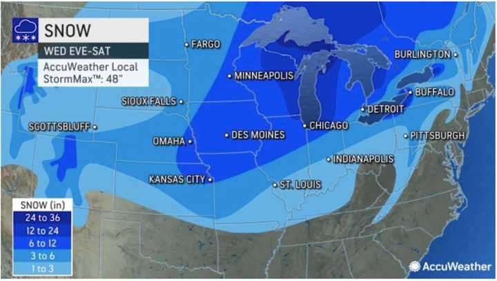
In fact, some parts of the Midwest could see up to 3 feet of accumulation, and significant snowfall in parts of upstate New York and northern New England.
Snowfall projections from AccuWeather.com are displayed in the image above:
- 1 to 3 inches (shown in the lightest blue),
- 3 to 6 inches (Columbia blue),
- 6 to 12 inches (blue),
- 12 to 24 inches (Royal blue),
- 24 to 36 inches (purple).
Currently, projections have the system winding down sometime on Saturday, with dry conditions expected on Christmas Day, which could be one of the coldest Christmases in years in some spots. High temperatures on Christmas could struggle to reach the mid 20s.
In most of this region, snowfall is not expected, but damaging winds could bring the potential of downed trees and power lines, leading to outages, along with possible rainfall amounts of 2 inches or more.
There's still uncertainty surrounding the system's precise projected timing, track, and potential strength.
Check back to Daily Voice for updates.
Click here to follow Daily Voice Manassas and receive free news updates.
