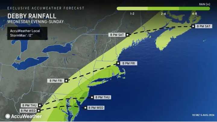
AccuWeather forecasters say episodes of drenching rain and heavy winds are working their way across the country and are expected to arrive in New Jersey, Pennsylvania, Virginia and Maryland on Tuesday, Aug. 6.
The above AccuWeather map shows which part of the region will be most impacted by the storms arriving Tuesday afternoon and lasting into the evening. Those include the Pennsylvania-Maryland border, South Jersey, and the Philadelphia and Baltimore areas.
Tuesday will be sunny and hot with a high of 90 before storms roll in, the National Weather Service says.
A flood watch is in effect from the National Weather Service from Tuesday afternoon into Wednesday morning for Hunterdon, Somerset, Middlesex, Monmouth, Mercer, Salem, Gloucester, Camden, Burlington, Ocean, Passaic, Hudson, Bergen, Essex, and Union counties in New Jersey. The flood watch was also in effect for Delaware, Philadelphia, Chester, Montgomery, and Bucks counties in Pennsylvania.
Wind gusts up to 70 mph, just under hurricane-strength, could arrive in Virginia and the New York City metro area, AccuWeather says.
"Tropical air from the periphery of Debby's influence will push up into the frontal zone from Tuesday to Wednesday, adding water to the air that will, in turn, be squeezed out," AccuWeather Senior Meteorologist Dave Dombek said. "This will enhance the downpours and correspondingly raise rainfall amounts to a higher level than if there had been no tropical moisture in the first place."
Storms are likely to subside Wednesday, Aug. 7, which will be mostly cloudy with a slight chance of rain and thunderstorms, the NWS said. Thursday, Aug. 8 will be similar to Wednesday's weather.
Come Friday, Hurricane Debby's impacts will have reached the mid-Atlantic and Northeast (see AccuWeather map above and below).
Debby's path is subject to change. Check back to Daily Voice for updates or click here for more from AccuWeather.
Click here to follow Daily Voice Doylestown and receive free news updates.


