The back-to-back storms will be followed by a blast of Arctic Air and a dangerous wintry mix with an accumulation of ice that could cause power outages on Sunday.
The first storm will come overnight Thursday night, Jan. 17 into Friday morning, Jan.18 with widespread 1 to 2 inches of accumulation.
Snow is expected to arrive around 11 p.m. Thursday and continue overnight before changing to a mix of rain, snow and freezing rain after daybreak.
The changeover to all rain will occur by about 7 a.m. along the coast. Precipitation will end by around 10 a.m. Friday, Jan. 18.
The rest of the day will be cloudy with a high temperature climbing to around 40 degrees.
Then, get ready for Round 2 as the more significant storm the National Weather Service describes as "multi-hazard" comes this weekend. A Winter Storm Watch is now in effect for the entire region from midnight Saturday, Jan. 19 until 6 p.m. Sunday, Jan. 20.
The major storm is expected to arrive after 4 p.m. on Saturday on a cloudy day with the high reaching the mid-30s.
Snow will mix with rain and sleet at times, and the storm could last 24 hours through Sunday night, Jan. 20, with the system wrapping up with evening snow showers.
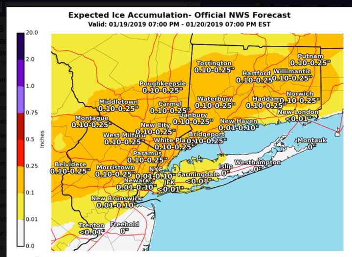
The wintry mix Sunday morning and Sunday afternoon could bring up to a quarter-inch of an accumulation of ice that could bring down power lines and cause outages. (See second image above.)
Most of the area will see 4 to 6 inches of snowfall accumulation with 6 to 12 inches expected farther north. (See first image above.)
The coldest air of the season moves in on Martin Luther King Jr. Day, Monday, Jan. 21, which will be mostly sunny and frigid, with a high of only about 10 degrees.
This continues to be a developing story. Check back to Daily Voice for updates.
Click here to follow Daily Voice Monroe and receive free news updates.


