Beryl was downgraded to a tropical storm late Monday morning, July 8, after it landed along the Texas coast as a Category 1 hurricane just before daybreak.
"Beryl's effects will be felt far beyond the Lone Star State this week as the storm will race north and east through the Midwest and then the Northeast, bringing heavy rain and a continued risk for a few tornadoes," according to AccuWeather.com.
Later on Tuesday, July 9, Beryl will merge with a frontal system as it treks north-northeast.
According to AccuWeather senior meteorologist Kristina Pydynowski, Beryl will transition into a tropical rainstorm as it moves farther inland.
"However, rain bands and squalls located to the east and southeast of Beryl’s center will contain a lot of spinning motion, which can spawn tornadoes," Pydynowski said.
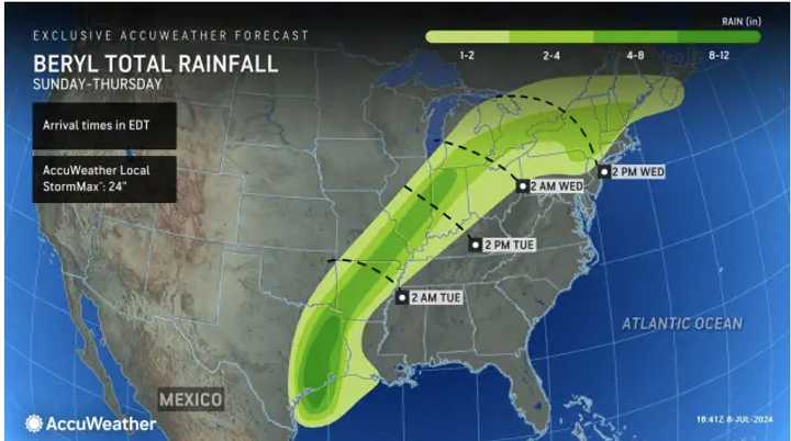
Rainfall from Beryl is expected to make its way to the Northeast late in the day Wednesday, July 10 into Thursday, July 11, when the region's most severe round of storms of the week are expected.
A widespread 2 to 4 inches of rainfall is predicted in the Northeast. (See the image above).
Areas farther south and along the coast should see around 1 to. 2 inches of rain.
Scattered afternoon and evening storms are possible in the region each day from Tuesday through Saturday, July 13, amid continued high heat and humidity.
Check back to Daily Voice for updates.
Click here to follow Daily Voice Hyde Park and receive free news updates.
