SHARE

Tornado Watch Now In Effect For Much Of Region

As Tropical Storm Isaias nears, a Tornado Watch has been issued for much of the region.

A look at areas (in yellow) covered by the Tornado Watch.

A look at areas (in yellow) covered by the Tornado Watch.

Photo Credit: National Weather Service
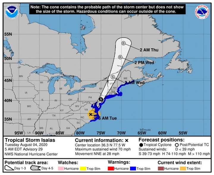
A look at the latest projected track for Isaias, released Tuesday morning, Aug. 4 by the National Hurricane Center.

A look at the latest projected track for Isaias, released Tuesday morning, Aug. 4 by the National Hurricane Center.

Photo Credit: National Hurricane Center
A look at projected rainfall amounts for Tropical Storm Isaias.

A look at projected rainfall amounts for Tropical Storm Isaias.

Photo Credit: AccuWeather
Wind strength for Tropical Storm Isaias.

Wind strength for Tropical Storm Isaias.

Photo Credit: AccuWeather

The watch is in effect until 4 p.m. Tuesday, Aug. 4. It is for areas mainly south of I-84 in New York and Connecticut. (See image above.)

The main threats with this the storm system are heavy rainfall, strong winds, minor to moderate coastal flooding, along with high surf and dangerous rip currents. 

The time frame for Isaias' strongest impact in this area is from about 3 p.m. to 11 p.m. on Tuesday.

A Tropical Storm Warning and Flash Flood Watch cover the entire region from 6 a.m. Tuesday to 6 a.m. Wednesday, Aug. 5. A Coastal Flood Advisory is in effect for areas along the coast.

This continues to be a developing story. Check back to Daily Voice for updates.

to follow Daily Voice Beekman-Poughquag and receive free news updates.

SCROLL TO NEXT ARTICLE