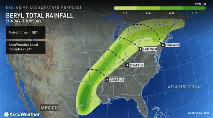
After making landfall as a Category 1 hurricane, Beryl is expected to continue traveling across the country, bringing torrential rain and thunderstorms through Central US before reaching Pennsylvania and New Jersey mid-week, AccuWeather reports.
According to the weather outlet, the Northwestern New Jersey and the northern-most portion of Pennsylvania will see one or two inches of rain from Beryl around 2 p.m. on Wednesday, July 10. AccuWeather is predicting up to four inches in Northeastern PA.
Fortunately, NJ and PA are not at risk of floods or drastic weather patterns, AccuWeather says.
And until then, the region will get much of the same as we've gotten since Saturday, July 6: Hot. Humid. Sticky — with a heat advisory for much of the region in effect until 10 p.m. Wednesday.
Tuesday, July 9 will mostly sunny with temps near 92, the National Weather Service says. Forecasters are calling for a slight chance of showers after 2 p.m.
Wednesday, July 10 will be just as hot but with more cloud coverage and with a higher chance of thunderstorms, the NWS said. This is the day that Beryl could hit, according to the AccuWeather forecast map, the northwestern-most parts of New Jersey and the northern third of Pennsylvania are at greatest risk.
If you've gotten this far in our weather story, you might be asking yourselves the same question we are: Will relief ever come?
A dip in temps, albeit slight, comes Thursday, July 11: A high of 89 with — you guessed it — a chance of thunderstorms. Friday will have a high of 87 with another chance of storms, the NWS said.
Temps are expected to rise again early next week.
Click here to follow Daily Voice Union City and receive free news updates.
