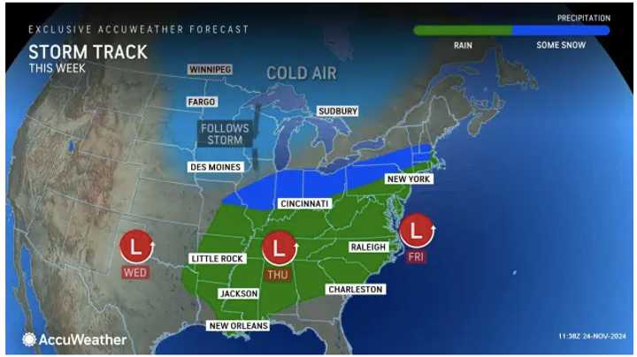
A pair of scenarios will be at play as the holiday week progresses, one of which could produce accumulating snow across portions of the Ohio Valley and Northeast, AccuWeather meteorologists say.
"The first scenario involves a slow-moving storm, meaning potentially longer-lasting impacts from the Tennessee and Ohio valleys through the Northeast," says AccuWeather.
"The second scenario sends the same storm farther south and off the Carolina coast through Thanksgiving. This would be a less intense storm with rounds of rain and even some snow, which could spread from the Tennessee Valley eastward to the East Coast."
The newest forecast models have the track veering in a more southerly fashion (the second scenario).
It will be blustery in the days leading up to the storm, with strong wind speeds and gusts through Tuesday, Nov. 26.
There will be a mix of sun and clouds Monday, Nov. 25, before a chance for showers overnight Monday into Tuesday.
There will be more showers and rainfall on Tuesday morning before skies gradually clear.
It will be partly to mostly sunny on Wednesday, Nov. 27, before clouds thicken Wednesday night.
The storm is expected to arrive farthest south early in the morning Thanksgiving Day on Thursday, Nov. 28 before it moves north.
The areas shaded in green in the image above are forecasted to receive the most rainfall from the Thanksgiving storm. Locations marked in blue may see a rain/snow mix, with accumulating snow possible.
Precipitation will linger into early Black Friday morning on Nov. 29 before skies becoming partly to mostly sunny.
There is still uncertainty surrounding the projected path and strength of the storm.
Check back to Daily Voice for updates.
Click here to follow Daily Voice Little Falls-Woodland Park and receive free news updates.
