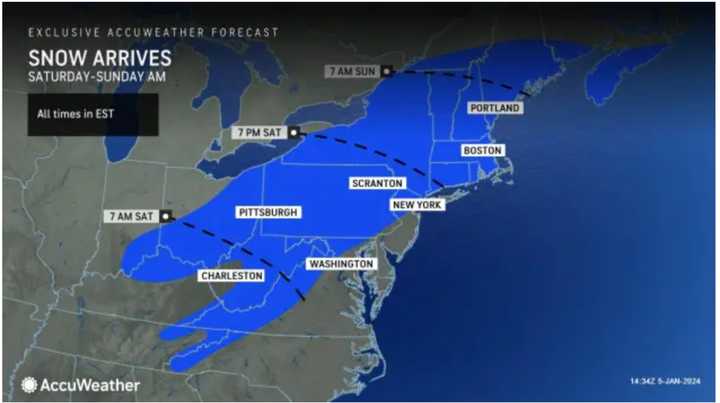
The system is expected to arrive in the Northeast beginning in western areas at around nightfall on Saturday, Jan. 6 before moving out Sunday afternoon, Jan. 7. (For storm arrival times, see the first image above from AccuWeather.com.)
Areas in the darkest shade of blue could in the second image above see between 12 and 18 inches of snowfall, with 6 to 12 inches possible in the surrounding shade of Columbia blue.
"In portions of New England, upstate New York, and in parts of Pennsylvania, the snow will fall at the rate of an inch per hour or more, and that could be difficult for road crews to keep up with," said AccuWeather Chief Meteorologist and Senior Vice President, Weather Content and Forecast Operations Jonathan Porter. "This could cause some motorists who venture out during the height of the storm from Saturday afternoon to early Sunday to become stranded on the highway."
The National Weather Service says there's still uncertainty as to whether there could be several inches of snowfall in parts of New York and on Long Island.
"Across the interior, snow amounts could occur at a location based on heavy snow banding location, duration and/or higher snowfall ratios," the weather service said. "Along the city/coast, snow amounts could be this high if transition occurs later and/or snowfall intensity is heavier than forecast Saturday night."
Motorists are being warned not to venture out in inland areas.
While the massive system will be relatively quick-moving, a second storm is expected just a couple of days later.
The National Weather Service is now saying the storm on track for Tuesday night, Jan. 9 into Wednesday, Jan. 10 could bring up to 4 inches of rainfall in parts of the Northeast.
With both storm systems, strong wind gusts are expected that could cause power outages, especially along the coast, and farthest east.
This continues to be a developing story. Check back to Daily Voice for updates.
Click here to follow Daily Voice Tarrytown-SleepyHollow and receive free news updates.

