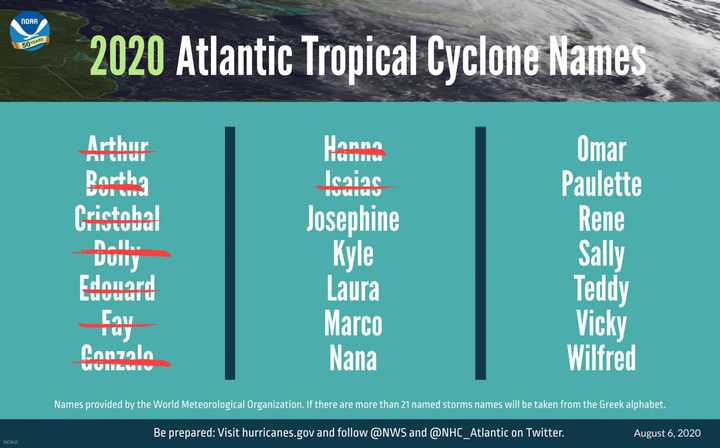
Hurricane turned Tropical Storm Isaias (pronounced "ees-ah-EE-ahs") became the earliest storm to begin with an "I" on record. The previous record was set on Aug. 7, 2005.
The first hurricane of the 2020 season, Hannah, became the earliest storm with an "H" name by nearly two weeks.
Now, if a newly released revised forecast is accurate, get ready for Josephine, Kyle, Laura and Marco with more to come. (See image above.)
The remainder of the season will be "extremely active," the National Oceanic and Atmospheric Administration said in a brand-new outlook released Thursday, Aug. 6.
We're only about one-third of the way through the hurricane season now, with the most active part still to come.
NOAA's scientists say that the atmospheric and oceanic conditions are primed to fuel storm development in the Atlantic.
The updated outlook calls for 19 to 25 named storms (winds of 39 mph or more), of which seven to 11 will become hurricanes (winds of 74 mph or greater), including three to six major hurricanes (winds of 111 mph or greater).
This update covers the entire six-month hurricane season, which ends Nov. 30, and includes the nine named storms to date.
"The outlook is for overall seasonal activity and is not a landfall forecast," NOAA said. "Landfalls are largely determined by short-term weather patterns, which are only predictable within about a week of a storm potentially reaching a coastline.
"The National Hurricane Center provides tropical weather outlooks out to five days in advance, provides track and intensity forecasts for individual storms, and issues watches and warnings for specific tropical storms, hurricanes and the associated storm surge."
To read the complete NOAA outlook, click here.
Click here to follow Daily Voice Scarsdale and receive free news updates.
