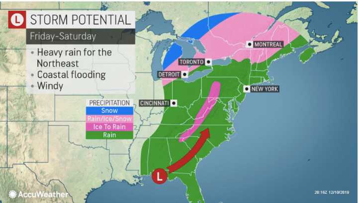
The first storm system will usher in the start of the weekend. But temperatures began to rise as it arrived on Friday afternoon, Dec. 13, keeping precipitation to rain.
Rain will be heavy at times in the evening and through the overnight with up to an inch of precipitation expected before daybreak. Temperatures will rise overnight to around the 50-degree mark.
A Flood Watch and Coastal Flood Advisory are both in effect until Saturday, Dec. 14 at 11 a.m.
Saturday will see rain, heavy at times, during the morning, with more rain at times through the evening, finally tapering off around midnight. Saturday's high temperature will be around 50 degrees. Wind gusts will be as high as 20 miles per hour Saturday night.
Another half-inch of rainfall is likely before the storm system will push out on Sunday, Dec. 15 as skies become partly sunny with the high temperature in the mid 40s.
After a partly sunny day on Monday, Dec. 16 with a high temperature in the mid to upper 30s, the next storm system will arrive.
There is uncertainty now surround the storm's potential with two potential tracks also possible.
Under the first scenario for the storm, in which it tracks farther south. areas north of I-287 in New York and the Merritt Parkway in Connecticut could see snow after 8 p.m. Monday, followed by a mix of snow and sleet through around 4 a.m. Tuesday, Dec. 17. (See Image 2 above.)
North of I-84, snow is likely between 8 p.m. Monday and 2 a.m. Tuesday., followed by sleet and freezing rain through late in the morning on Tuesday, followed by rain.
South of I-287 and the Merritt Parkway, including on Long Island, look for a mix of rain, snow, and sleet between midnight and 1 a.m. Tuesday, followed by rain.
There could be more of a wintry mix for most of the region if the storm tracks farther north under Storm Scenario 2. (See the third image above.)
The entire region will see rain at times until around 8 p.m. Tuesday.
Skies will gradually clear late in the evening and overnight, leading the way to a mostly sunny and cold day on Wednesday, Dec. 18, with the high temperature in the low 30s.
Click here to follow Daily Voice Rivertowns and receive free news updates.


