


A slow-moving major Nor'easter will dump mixed precipitation along with heavy snow at times, creating dangerous and difficult travel for both those heading home from Thanksgiving on Sunday, Dec. 1 and those headed back to work on Monday, Dec. 2.
Winter Storm Watches, in effect from 7 a.m. Sunday, Dec. 1 until 7 p.m. Monday, Dec. 2, now cover Northern Westchester, Putnam, Dutchess, Rockland, Orange, Ulster and Sullivan counties in New York and Northern Fairfield and Litchfield counties in Connecticut.
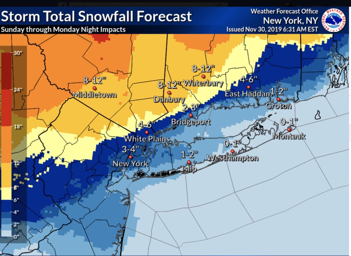
Areas north of New York City and south of I-287 and the Merritt Parkway will see anywhere between 3 to 4 inches of snowfall, with locally higher amounts. North of I-287 and the Merritt, between 4 to 12 inches is expected.
The north shore of Nassau County will see between 1-2 inches of snowfall, but in Suffolk County, look for no more than a trace, with an inch possible in some spots, according to the National Weather Service. (Image 1 above.)
Portions of Dutchess and Ulster counties could see up to 18 inches of snowfall. (See third image above.)
For the latest projected snowfall accumulations by AccuWeather.com, check the second image above.
After a dry and partly cloudy day on Saturday, Nov. 30 with a high temperature around 40 degrees, a wintry mix with rain and snow will move across the entire region Saturday night into Sunday, Dec. 1.
There will be snow at times during the day on Sunday, especially farther inland.
The heaviest snow from the storm will fall on Monday, especially in the counties where the watches are in effect. But even areas south of I-287 and the Merritt Parkway, including most of New York City, southern Westchester, coastal Connecticut and the north shore of Long Island, should see 3 to 5 inches of snow. (See image above.)
Farther inland, 5 to 8 inches of accumulation is now expected. Some areas north of I-84, including Ulster and Dutchess, could see 12 to 18 inches of accumulation.
The storm could linger long enough to affect the morning commute on Tuesday, Dec. 3.
"This will be a long, drawn-out event," the National Weather Service said in a statement released late Friday afternoon, Nov. 29. "There looks to be a lull Sunday night and although precipitation won't stop completely, there looks to be intermittent light snow and a wintry mix through the night.
"Steady snow will redevelop across the entire area for Monday, with moderate to heavy snowfall possible once again. Snowfall looks to taper off Monday evening."
Check back to Daily Voice for updates.
Click here to follow Daily Voice Pleasantville and receive free news updates.