The storm will follow something of a spring fling to start the week and a rare nearly snow-free month of February.
Wednesday, March 4, will feature a mix of sun and clouds with the high temperature in the low to mid 50s. It will be gusty with wind strength between 14 and 18 miles per hour and gusts up to near 35 mph.
Skies will become cloudy overnight with a slight chance for showers after midnight.
Thursday, March 5 will be sunny with the high temperature around 50 degrees.
The storms will move toward the area on Friday, March 6, which will be cloudy throughout the day with the high temperature will be in the low to mid 40s.
The chance for precipitation arrives around noontime on Friday.
As the temperature falls Friday evening -- with the overnight low in the upper 20s -- rain showers will change over to snow after around 10 p.m.
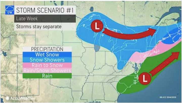
If Scenario 1 (first image above) plays out and the storms stay apart, the area should see mainly a wintry mix.
But if the storms merge (Scenario 2 in the second image above), much of the region could see accumulating snowfall with significant totals possible farthest north and inland, and especially west.
It's too early to predict potential snowfall totals as the storm tracks remain uncertain.
Skies will clear as the storm pushes out before daybreak on Saturday, March 7, which will gradually become mostly sunny with a high temperature in the low 40s.
Sunday, March 8 will be sunny with the high temperature in the low to mid 50s.
Check back to Daily Voice for updates.
Click here to follow Daily Voice Mount Vernon and receive free news updates.

