Find Your Daily Voice
Union
Your Local News for Union County, New Jersey
Tuesday, apr 16
54°
Follow
News
Schools
Business
Obituaries
Police & Fire
Weather
Lifestyle
Politics
Sports
Events
Traffic
Real Estate
Tags
Jobs
Shop
Support Us
Union
Follow
Find Your Daily Voice
News
Schools
Business
Obituaries
Police & Fire
Weather
Lifestyle
Politics
Sports
Events
Traffic
Real Estate
Tags
Jobs
Shop
Support Us
Home
About us
All sites
Advertise with us
Contact us
Terms of use
Privacy policy
Code of ethics
Site Map
© 2024 Cantata Media
54°
Tuesday, apr 16
Weather
Possibility Of Snow, Ice Storm For Northeast Next Week Hinges On One Factor: AccuWeather
A winter storm could hit the Northeast next week, but it depends on one factor, forecasters say. A dip in the jet stream. “Should a large dip develop in the jet stream, then a major winter storm will climb the Atlantic coast from Monday night to Tuesday night,” AccuWeather Senior Meteorologist Bob Smerbeck explained. “However, should only a shallow dip in the jet stream develop, the storm would be more likely to escape out to sea, off the southern Atlantic coast by midweek.” Weather maps show a dusting of between one and three inches, should the snow make its way up to New Jersey, eastern…
Weather
'Arctic Blast:' Snow, Ice To Threaten Northeast After Windy, Rainy Start To Weekend
Forecasters are tracking two more storms in the coming days: One bringing heavy rain and wind, the other snow and ice to the Northeast. Thursday, Jan. 11 will be partly sunny with a high near 45 while Friday, Jan. 12 will be the same, before rain begins in the evening, the National Weather Service says. The heaviest rain will fall at night and could result in major flooding adding to the damage for the mid-week storm. Quieter conditions are expected today before the next system arrives Friday afternoon into the weekend. Expect another... Posted by US National Weather Service Bal…
Weather
Falling Tree Misses Officer, Major Roadways Flooded: North Jersey Storm Damage Update
North Jersey residents are feeling the impact of this week's storm with thousands still without power and schools closed or delayed. In Bergen County, houses were hit on East Midland Avenue in Paramus and on Sunset Avenue in Englewood. A Mahwah police officer also escaped serious injury when a falling tree struck his cruiser. Route 17 was closed in both directions at various times in multiple spots, including in Hasbrouck Heights around 9:30 p.m., in East Rutherford just before midnight and in Rochelle Park about an hour later. A stretch of Route 46 in Lodi also was under water, as we…
Weather
Another Storm Nears: Weather Service Warns Of Event Causing More Flooding In NJ, PA
Yet another storm system is working its way toward the region, the National Weather Service warns. Northern New Jersey and Southeast Pennsylvania will remain in a flood stage through the end of the week, when the second storm is set to arrive, the NWS said. That storm will begin Friday evening, Jan. 12, with rainfall continuing overnight into Saturday, Jan. 13, the weather service said. That storm will also be accompanied by new flooding and damaging winds. While recovery is underway from the storm that affected our region last night, another storm is gearing up to affect our... Posted…
Weather
State Of Emergency: 65 MPH Winds, Flash Flooding Expected In Severe Storm Headed To New Jersey
Gov. Phil Murphy declared a State of Emergency as all of New Jersey was under multiple weather alerts and advisories on Tuesday, Jan. 9, ahead of a storm expected to pound the region with heavy rain and gusty winds. Between 1 and 3 inches of rain is expected across the state with up to 65 mph winds that could cause power outages and uprooted trees, according to the National Weather Service. ⚠️ State of Emergency effective at 5:00 p.m. on Tuesday, January 9 in anticipation of severe storms causing hazardous weather conditions including heavy rain 🌧️ , high winds 💨, and flash flooding 🌊. —…
Weather
Tracking Major Mid-Week Winter Storm Set To Blast Region With Heavy Wind, Rain
A new winter storm on the heels of the last is set to blast the Northeast with heavy rain and winds, the National Weather Service said. Monday, Jan. 8 will be sunny with a high in the mid-40s and Tuesday, Jan. 9 will be even warmer and breezy, with a high near 50, but with a chance of rain, the NWS said. That rain is set to begin around 1 p.m., and will be accompanied by heavy winds as the day progresses, forecasters say. The NWS imposed a wind advisory beginning the evening of Jan. 9 for much of the Northeast. Between 1 and 3 inches of rain is expected to fall in across the entire region,…
Weather
How Accurate Were NWS' Snowfall Predictions In North Jersey? Let's Compare Maps
The National Weather Service has released an automated analysis of snowfall after the Saturday, Jan. 6 storm. Let's see how accurate the NWS' prediction models were compared to the model released after the storm. The weather service initially said nearly all of Sussex County and large portions of Morris and Warren counties would get a foot of snow. Wanatage in Sussex County was expected to get the most snow. A foot of snow or more fell there, but the areas around it like Sussex, Hamburg and Branchburg, Blairstown and Hardwick saw something closer to 8 or 10 inches, the NWS analysis s…
Weather
Snow Predictions Increase From National Weather Service For Parts Of NJ, PA (
Timing
)
The National Weather Service has released its latest snowfall predictions for New Jersey and parts of eastern Pennsylvania ahead of this weekend's storm. HOW MUCH SNOW? Good Saturday morning. It is a cold start to the day, however a storm arriving by later today will bring accumulating... Posted by US National Weather Service Philadelphia/Mount Holly on Saturday, January 6, 2024 Up to a foot of snow is expected to fall in Sussex, Morris, Passaic, and Warren counties, and even a small portion of northwestern Bergen County, beginning Saturday afternoon, Jan. 6, the NWS' latest weathe…
Weather
Tracking Weekend Snow, Mid-Week Rain Storms Both Heading Toward Northeast
Parts of the region will be shoveling out of several inches of snow from the weekend when another strong storm system moves in, forecasters are saying. On Friday, Jan. 5, the National Weather Service released a new model showing between eight and 12 inches of snow in Sussex and Warren counties in New Jersey, and the Pocono mountains in PA (scroll for map). The chance of snow isn't looking good for greater Philadelphia this weekend, the NWS says, noting snow-lovers in the area will be "disappointed" by this weekend's system. "Our latest forecast has only a 3% chance of seeing 1" or more of …
Weather
New Forecast Map: 7 Inches Of Snow Could Fall In Parts Of NJ This Weekend
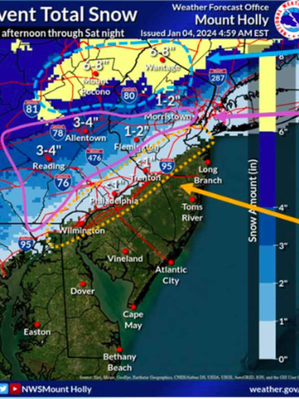
Some parts of New Jersey and the Lehigh Valley/Pocono mountains could get up to seven inches of snow this weekend, according to newly-released forecast maps. The National Weather Service's Mount Holly office released a new forecast map on Thursday, Jan. 4 — two days before heavy snow is expected to make its debut after nearly two years in the Northeast. ⚠️❄️ A coastal system will bring widespread precipitation to our region. Snow and some mixed precip will occur northwest... Posted by US National Weather Service Philadelphia/Mount Holly on Thursday, January 4, 2024 ⚠️ A lot of …
Weather
Another Impactful Storm To Follow Snowy Weekend In Northeast: Forecasters
Forecasters are touting a massive storm expected to drop several inches of snow on the East Coast this weekend. But some weather maps show parts of the Northeast will get only rain, and no snow at all, noting a another impactful storm could be coming mid-week next week, AccuWeather reports. The storm coming Saturday, Jan. 6 will move northeast from the Gulf Coast toward the mid-Atlantic between 12 and 1 p.m., according to AccuWeather and the National Weather Service. Our first chance for some accumulating and potentially impactful snowfall this season will occur for some this wee…
Weather
First Projected Snowfall Totals Released For Major Storm Headed To Northeast
The first projected snowfall totals have been released for a potent coast-to-coast winter storm expected to hit the Northeast midway through the weekend. Click here for a new, updated story - Projected Snowfall Totals Increase As Nor'easter Nears: These Spots Could See 18 Inches Snowfall is expected to begin overnight Saturday, Jan. 6 into Sunday, Jan. 7, according to the National Weather Service. Areas in the darker shade in the image above from AccuWeather.com are expected to see between 6 and 12 inches of snowfall, including parts of upstate New York, northern Connecticut and areas…
1
2
3
4
5
6
7
8
9
10
Archive