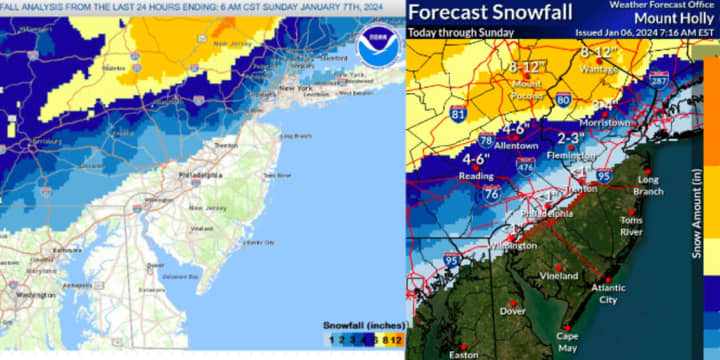
Let's see how accurate the NWS' prediction models were compared to the model released after the storm.
The weather service initially said nearly all of Sussex County and large portions of Morris and Warren counties would get a foot of snow.
Wanatage in Sussex County was expected to get the most snow. A foot of snow or more fell there, but the areas around it like Sussex, Hamburg and Branchburg, Blairstown and Hardwick saw something closer to 8 or 10 inches, the NWS analysis shows.
The northernmost part of Morris County saw between 6 and 8 inches of snow, but most of the county such as Pompton Lakes, Parsippany, Morristown and Mendham saw about 3 or 4 inches, which is what the NWS predicted. Northern Passaic County got the same.
The most snow that fell in Bergen County appeared to have been in Franklin Lakes, Mahwah, Ramsey and parts of Wyckoff which got 4 inches.
The snowfall totals seemed to taper off further southern and easter parts of Bergen County. Glen Rock got 4 inches, River Vale got between 2 and 3, and East Rutherford got .5 inches, NJ Advance Media reports.
The same pattern holds true for Essex County where Newark got a dusting but North Caldwell got 4.4 inches, the outlet said. In Hunterdon County, the municipality with the most snow was Bethlehem Township with 5 inches, and Frenchtown got the least with 2.2, NJ.com says.
Click here to follow Daily Voice South Passaic and receive free news updates.


