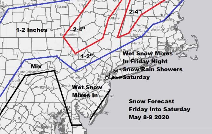
"It is hard to believe that we are looking at snow forecast maps during the month of May but such is life these days," Cioffi said Thursday. "This weekend is going to be very cold and windy but it should be nice and sunny for Mothers Day."
“For the coast and most areas it will just be some wet snow mixing in Friday night as low pressure goes by,” Cioffi said.
“Well inland in extreme northwest New Jersey and into northern Pennsylvania, as well as upstate NY and New England down to Route 84 in Connecticut, this is where you could wind up with a coating to a couple of inches mainly on colder surfaces and in elevated areas above 1500 feet or so.
“That means the Catskills, Poconos, Berkshires, and Adirondacks should see the highest amounts," he said.
Amounts will be highest in Maine – three to six inches, even – “but, then again, it is Maine,” said Cioffi, who's trademarked the "Joestradamus" moniker. Highs on Friday will be in the 50s, he said.
“The main threat for snow will be after 8 p.m., with mixing occurring along the coast after 11 p.m.," he said. "It is mostly gone by Saturday daybreak.”
Saturday will have what Cioffi called “ineffective” sunshine, with the chance of a few rain showers as this unusually cold period continues. Highs in most areas likely won’t get out of the 40s, he said.
Then comes the frost overnight Saturday into Mother’s Day, when temperatures climb back into the upper 50s with plenty of sunshine, Cioffi said.
“The good news is that the cold pattern relaxes later next week as temperatures trend back to normal or even above normal for next weekend,” he said.
SEE: WEATHER UPDATES 24/7 BY METEOROLOGIST JOE CIOFFI
Click here to follow Daily Voice Pascack Valley and receive free news updates.
