That means travel will be “very difficult to impossible” beginning with the arrival of the prolonged storm around 7 p.m. Sunday and continuing through 1 p.m. Tuesday, the National Weather Service said Sunday morning.
There will also be power outages from downed trees and snagged wires, as well as flooding in coastal areas.
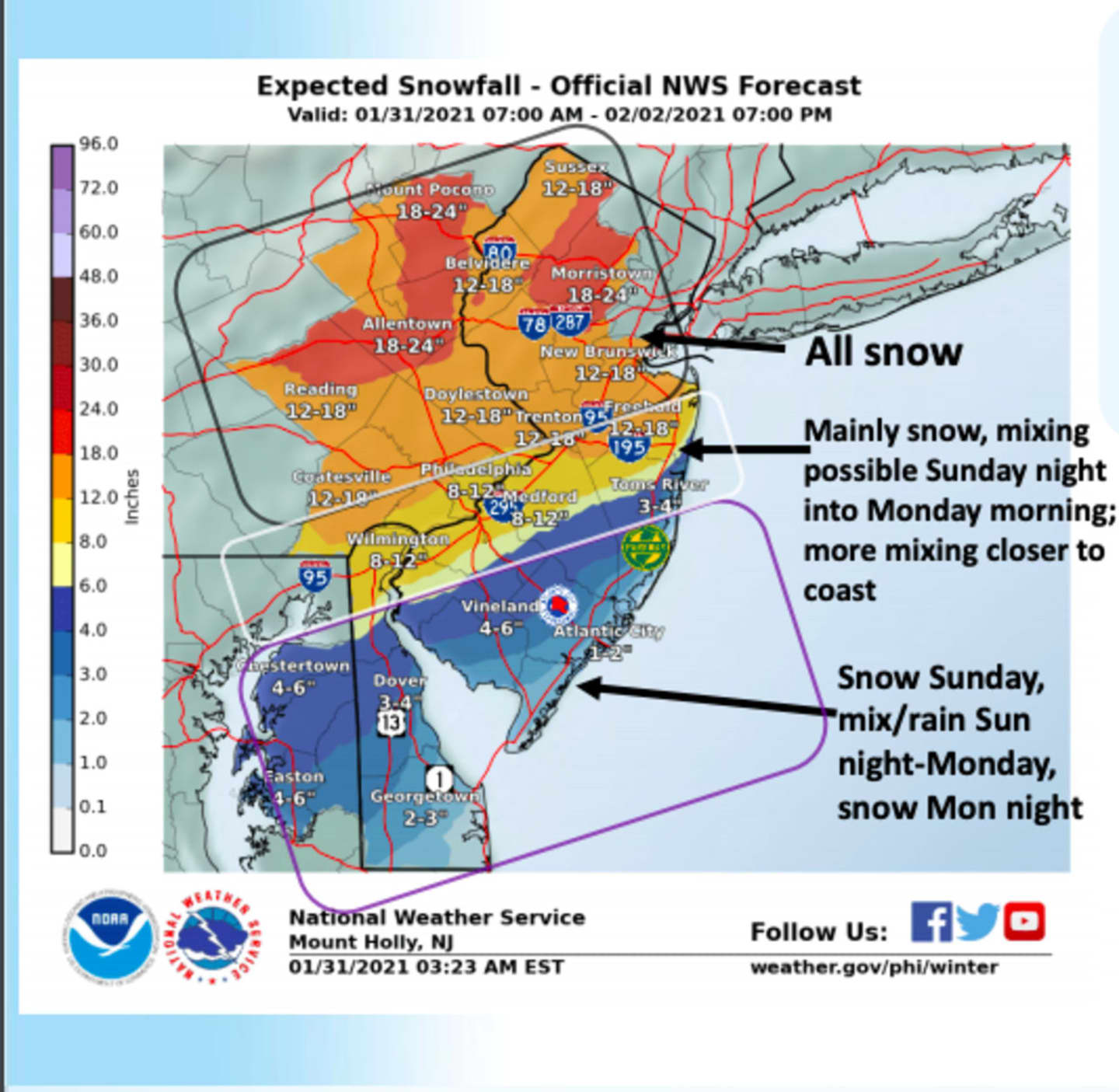
Morris, Sussex and Warren counties are expected to get the worst of it, with anywhere from 15 to a whopping 24 inches of snow possible, the NWS said around noontime Sunday.
Most of it will fall during daylight Monday at a projected clip of an inch an hour during its height, the service said.
The greater Philadelphia area could get a foot to 18 inches, with severe warnings issued for parts of the Poconos and Allentown.
Parts of the Jersey Shore, meanwhile, could have as little as two to 4 inches, the service said.
Here's how the other New Jersey counties shaped up as of the NWS Sunday forecast:
Bergen, Passaic, Hudson, Essex and Union counties: 14 to 18 inches, with blizzard-like conditions (wind gusts 35-45 miles an hour).
Somerset, Hunterdon, Middlesex and Mercer counties: 13 to 18 inches, gusts up to 35 mph.
Monmouth, northwest Burlington: 7 to 14 inches, with sleet and rain affecting the total, but gusts up to 45-50 mph.
Ocean, southeast Burlington: 6 to 8 inches, with the same effect of mixed precipitation and wind gusts up to 45-50 mph.
Salem, Gloucester and Camden counties: 8 to 12 inches, with a mix of sleet and rain, but with ice.
Atlantic, Cape May, Cumberland and coastal Ocean: Two to 4 inches, mixed.
Among the major concerns: travel and power outages from downed wires.
Blowing and drifting snow should give drivers fits. Road conditions overall will be treacherous -- or, to quote the weather service, “very difficult to impossible” -- from Sunday night through much of Monday.
A coastal flood watch was issued from 7 a.m. Monday to 5 p.m. Tuesday in coastal Ocean, Atlantic and Cape May counties, as well as in eastern Monmouth, Middlesex, Ocean, southeastern Burlington and western Monmouth counties.
Roads in coastal and bayside towns could “become impassible,” the weather service warned. “Some damage to vulnerable structures may begin to occur.”
If you must travel, the service said, keep an extra flashlight, food, and water in your vehicle in case of an emergency.
Click here to follow Daily Voice North Passaic and receive free news updates.