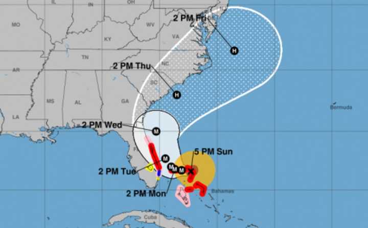
South Carolina and Georgia’s governors ordered mandatory coastline evacuations beginning at noon on Labor Day and school and state office closings on Tuesday, as the historic hurricane took aim at the East Coast.
South Carolina Gov. Henry McMaster also ordered immediate medical evacuations on Sunday -- including hospitals, nursing home, psychiatric facilities and assisted living, hospice and birthing centers.
Although landfall wasn't a certainty, forecasters said tropical winds of up to 70 miles an hour and more than 10 inches rain could cause severe damage in areas that include Charleston, S.C.
"Dorian continues to move to the west but it has slowed down now to 5 mph and seems to be behaving on track," he reported Sunday night.
"The upper ridge is weakening and upper air steering winds continue to collapse," Cioffi said. "Dorian will slow to a crawl and may not emerge from the Bahamas until sometime Tuesday when it begins to move more to the north."
The northwestern Bahamas would take a beating until then, with possible storm surges of as much as 18 to 23 feet -- enough to flood the island's many low-lying areas -- along with more than two feet of rain.
Dorian isn't expected to make landfall in Florida, though the eye will possibly come within 50 to 60 miles, enough to cause wind and water damage, Cioffi said.
The National Hurricane Center issued hurricane warnings from just north of Jupiter Inlet to near Sebastian Inlet.
"There will be gales developing along the immediate coast Monday night and Tuesday as well as tidal flooding and beach erosion," Cioffi said. "Rain is also likely once the hurricane begins its northward motion."
However, he said, it "really doesn’t stand out much than on any other September day in South Florida."
"Once Dorian starts moving northward and the storm expands, we will see the storm weaken gradually," Cioffi said. "It can’t hold on to this extreme strength forever and the ocean water temperatures further north, while warm, are not supportive in maintaining a Category 5 hurricane for a long period of time."
Georgia and South Carolina likely could expect heavy rain and wind in the middle of the week, he said, with "some of watches and warnings eventually being put up for parts of the Southeast coast in the next day or so."
Various tentative models show the center of Dorian clipping North Carolina's Outer Banks on Friday before passing south and east of Cape Cod by Saturday morning, Cioffi said.
Click here to follow Daily Voice Northern Highlands and receive free news updates.
