On Tuesday, while acknowledging "the path is still uncertain," Moore cited "possible effects on Maryland could include heavy rain and winds, inland and tidal flooding," while making the declaration.
During a State of Preparedness, officials say that is allows the state to enhance its ability to respond swiftly and effectively to potential hazards and threats in advance of an actual disaster.
The order order directs the Department of Emergency Management to coordinate the comprehensive preparation of state government ahead of potential impacts from hazards or threats, providing a vital layer of protection for Marylanders without necessitating a State of Emergency, which was declared in Virginia.
“The safety of Marylanders is our top priority. By declaring a State of Preparedness, I am directing the Department of Emergency Management to coordinate the comprehensive preparation of State government ahead of potential impacts from the remnants of Tropical Storm Debby," Moore stated.
"Residents and visitors should monitor local weather forecasts, remain vigilant, and be prepared to follow safety instructions from local emergency officials.”
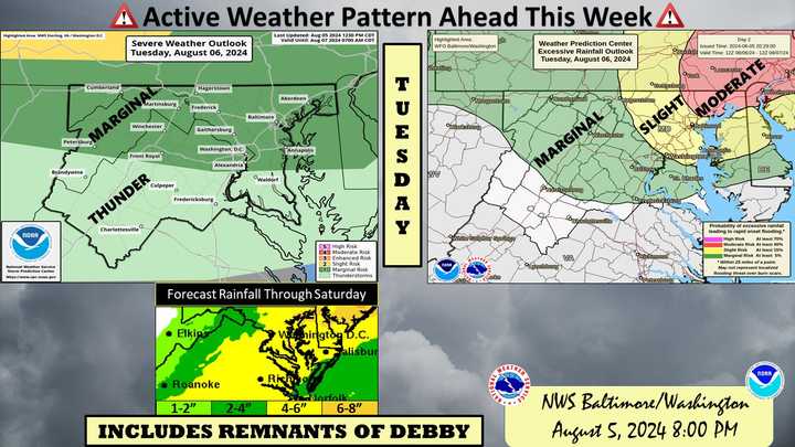
According to the National Weather Service, there is an increasing threat for heavy rainfall through the DMV region, with a warning issued through 4 a.m. on Wednesday morning.
Multiple rounds of thunderstorms are expected, some of which may produce torrential downpours, forecasters cautioned.
The deadly tropical storm wreaked havoc in the Southwest after making landfall in Florida this week, including five reported deaths, according to AccuWeather.
Debby is expected to continue moving north, prompting the governor's precautionary plan to call for the State of Preparedness with storms expected to arrive in the area on Wednesday, Aug. 7.
Rain is possible beginning Tuesday with thunderstorms and continuing through Friday.
"The latest National Hurricane Center forecast for Tropical Storm Debby brings potential remnants into the Mid-Atlantic later this week and into the weekend," officials said.
At this time, rain, heavy at times, and tidal flooding are the main threats. Uncertainty exists regarding the track over the Mid-Atlantic, which will greatly influence rainfall amounts.
Based on the latest National Hurricane Center forecast, the main impacts would be later Thursday into Saturday, according to forecasts.
Impacts will be dependent upon how long Tropical Storm Debby sits on the Southeast US Coast and tracks into the Mid-Atlantic, officials said.
Want breaking news in the DMV as it happens, or want to contribute? Join the DMV All Incidents Facebook group.
Click here to follow Daily Voice Taneytown-Union Bridge and receive free news updates.
