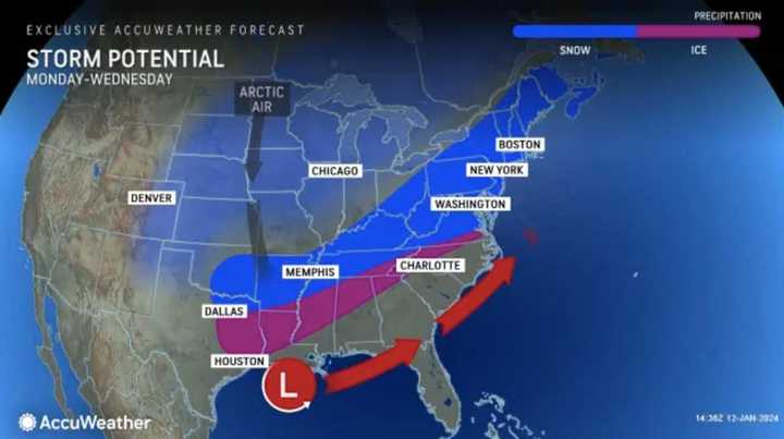
A dip in the jet stream.
“Should a large dip develop in the jet stream, then a major winter storm will climb the Atlantic coast from Monday night to Tuesday night,” AccuWeather Senior Meteorologist Bob Smerbeck explained.
“However, should only a shallow dip in the jet stream develop, the storm would be more likely to escape out to sea, off the southern Atlantic coast by midweek.”
Weather maps show a dusting of between one and three inches, should the snow make its way up to New Jersey, eastern PA, and Maryland.
The storm will travel over the southern states and reach the East Coast on Monday, Jan. 16, the weather outlet said. Should the jet stream buckle, then the storm will turn northward, Smerbeck said. If not, the storm will continue over southern Virginia and the Carolinas.
"Based solely on the overall pattern, weighing all the options, a storm seems likely to evolve along the Atlantic coast with the potential for plowable snow in the I-95 corridor of the mid-Atlantic and New England, with rain more likely over Delmarva, the New Jersey shore, Long Island, New York, and southeastern New England," AccuWeather Senior Long-Range Meteorologist Joe Lundberg added.
Meanwhile, flooding continues to be a threat over the weekend. Saturday, Jan. 13 will be close to 60 degrees and windy, while Sunday, Jan. 14 will have a high of 45 and a chance of rain.
MLK Day will be cold and cloudy, the NWS says.
This continues to be a developing story. Check back for details and here for more from AccuWeather.
Click here to follow Daily Voice Mechanicsville and receive free news updates.

