Storms are expected to continue overnight, with upwards of four inches of rain possibly pouring in parts of the area, leading to increased risk of floods and "tropical downpours" as the storm continues to travel up the East Coast.
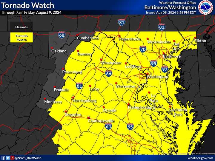
The Tornado Watch was issued at 7 p.m. on Thursday, Aug. 8, and will continue through 7 a.m. on Friday morning.
According to the National Weather Service, the tornado threat will increase from southern and eastern Virginia overnight.
Storms are expected to continue drenching the area through Friday, possibly causing chaos for some commuters in the morning.
"A southerly wind initially will cause water to pile through the Chesapeake Bay with no way to escape, meaning water rises of over 3 feet above the routine tides around Baltimore and Annapolis, Maryland," AccuWeather Senior Meteorologist John Feerick said,
"There will also be coastal flooding during times of high tide along the Delaware Bay and the tidal portion of the Delaware River into the Philadelphia area.
During the storms, wind gusts may reach up to 40 mph on the water, while reaching up to 35 mph inland, and higher along the ridges.
"Along with torrential downpours, severe thunderstorms packing strong wind gusts are likely," AccuWeather forecasters said. "Because Debby has shown a history of triggering tornadoes on its eastern flank, meteorologists believe that trend will continue throughout its duration in the United States.
"Another concern is that some of the tornadoes will occur during heavy rain or at night, when they may be hard to spot in advance."
Want breaking news in the DMV as it happens, or want to contribute? Join the DMV All Incidents Facebook group.
Click here to follow Daily Voice Leonardtown-California and receive free news updates.
