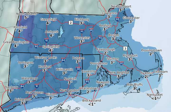
Anywhere between 2 inches and 5 inches of snowfall is anticipated for parts of Central and Western Massachusetts on Tuesday, Feb. 9, and possibly into Wednesday, Feb. 10, according to the National Weather Service.
Expect the snow to start falling early on Tuesday, between 6 and 7 a.m. in the Berkshires and Pioneer Valley and more towards 9 a.m. for Worcester and Fitchburg.
For the most part, the Pioneer Valley, Southern, and Central Berkshires can expect about 4 inches of snow.
Towards Central Massachusetts and Worcester, snowfall totals are anticipated to be around 3 inches.
In the North Berkshires snowfall may add up to 5 inches, the National Weather Service said.
Forecasters are fairly certain about the predictions noting there is more than a 90 percent chance of snow on Tuesday. Significant ice build-up is not anticipated.
For today, Monday, Feb. 8, the forecast calls for sunny skies with a high near 24 degrees and a wind chill value as low as -1. Winds will be gusty at around 10-14 mph with occasional blasts reaching 24 mph. The low will be around 12.
More snow is predicted on Thursday night and Friday morning, but no snowfall totals have been announced. The chance of snow on these days is 40 percent, the National Weather Service said.
Click here to follow Daily Voice Springfield and receive free news updates.

