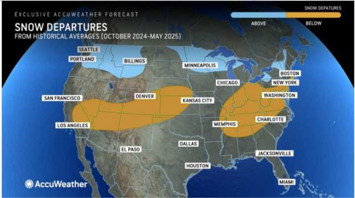
In the image above, higher-than-average snowfall is predicted for those areas shown in light blue, with most areas in the Northeast are expected to receive more snow this season than last winter.
Areas in the darker shade are expected to see below average snowfall in 2024-25, including in much of the Mid-Atlantic states.
AccuWeather Senior Meteorologist and Long-Range Expert Paul Pastelok says big changes will unfold during the opening weeks of 2025, as a new weather pattern will likely lead to milder temperatures and less snow across the eastern half of the nation.
A backend surge to winter could bring the potential for multiple snowstorms from the Great Lakes, Ohio Vally and through the Northeast, Pastelok notes. The risk of snow may also be accompanied by the polar vortex, a rotating system located near the north or south pole.
A weaker La Niña predicted for most of this winter is expected to keep temperatures more than 3 degrees above the historical average in much of the Gulf Coast and south-central region.
The La Niña phenomenon occurs when water temperatures near the equator in the eastern Pacific Ocean remain below the historical average for an extended period, which can significantly influence weather patterns across North America, including the trajectory of snowstorms.
"During a strong La Niña we typically see a dominant storm track over the northwest US and western Canada," Pastelok said. "This can result in periods of mild Pacific air moving across the central and eastern US at times. However, with a weak signal of La Nina, some cold can make pushes into the Midwest and Northeast."
The demand for heating this winter will be below the historical average across roughly 75 percent of the US this season, AccuWeather says.
Check back to Daily Voice for updates.
Click here to follow Daily Voice Roslindale and receive free news updates.
