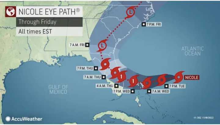
A Hurricane Watch has been issued along Florida's East Coast as now Tropical Storm Nicole makes its way toward the East Coast.
Nicole, located about 380 miles east-northeast of the Bahamas as of early Tuesday morning, Nov. 8, is moving northwest.
A turn toward the west and west-southwest is expected later in the day, and that motion should continue through Wednesday, Nov. 9, the National Hurricane Center said.
A turn toward the northwest and north-northwest is expected Thursday, Nov. 10.
Nicole now has maximum sustained winds of around 50 miles per hour with higher gusts, the hurricane center noted.
Gradual strengthening is forecast during the next few days, and Nicole is forecast to be at hurricane intensity by Wednesday night, while it is moving near or over the northwestern Bahamas.
"On the forecast track, the center of Nicole will approach the northwestern Bahamas today and tonight, move near or over those islands on Wednesday, and approach the east coast of Florida Wednesday night," the hurricane center said. Tuesday morning. "Nicole's center is then expected to move across central and northern Florida into southern Georgia Thursday and Thursday night."
"In coastal areas, especially from the Space Coast of Florida through the Carolinas, tropical-storm-force wind gusts can occur for 36-48 hours straight," said AccuWeather Director of Forecasting Operations Dan DePodwin. "This is a longer duration than typical tropical systems."
- For the National Hurricane Center's projected timing and track for Nicole, see the first image above.
- For the latest timing and track for Nicole from AccuWeather.com, click on the second image above.
- For projected impacts from Nicole in the Northeast from Friday, Nov. 11 through Sunday, Nov. 13, click on the third image above.
The 2022 Atlantic hurricane season, which began on Wednesday, June 1, ends on Wednesday, Nov. 30.
This continues to be a developing story. Check back to Daily Voice for updates.
Click here to follow Daily Voice Windham-Willimantic and receive free news updates.


