It became a Category 1 hurricane around 11 a.m. Saturday, Aug. 21.
Hurricane and Storm Surge Warnings are in effect for portions of Long Island, and southern New England with Tropical Storm Warnings elsewhere.
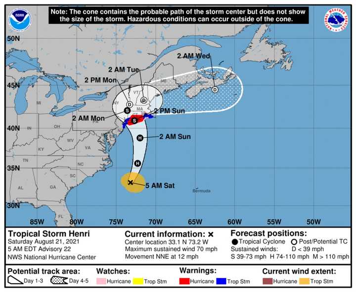
Henri (pronounced ON-ree) is now expected to accelerate northward on Saturday, and make landfall on Long Island or southern New England on Sunday, Aug. 22.
In addition to hurricane conditions and dangerous surge, heavy rainfall may lead to considerable flooding in parts of the region Sunday into Monday, Aug. 23.
The latest models were released Saturday morning by the National Weather Service NOAA National Hurricane Center.
If it strengthens to hurricane status as expected, Henri could be the first hurricane to make landfall in New England since Bob in 1991.
Henri is currently about 500 miles south of Montauk Point and will likely track north northeast across Long Island on Sunday, and then track into southern New England and upstate New York later Sunday into Monday.
The main threats from Henri are:
- Potentially life-threatening storm surge,
- Heavy rain capable of producing flash flooding,
- Tropical storm or hurricane-force winds along the south shore and Long Island and across southern Connecticut.
- There will also be associated marine and coastal hazards, including very rough seas and dangerous rip currents.
- Severe beach erosion is possible for coastal areas of Long Island Sound and portions of Suffolk County, including the Twin Forks region.
Widespread rainfall of 3 to 6 inches is forecast in the path of Henri with localized higher amounts possible Saturday through Sunday night.
The highest amounts are forecast to be across eastern Long Island and much of southern Connecticut. This will present a likelihood for areas of flash flooding.
Dangerous marine conditions are likely on the ocean waters south of Long Island, as well as on Long Island Sound, and the south shore and eastern bays of Long Island. Hurricane-force winds will be most likely in those areas.
A Hurricane Warning is in effect for:
- South shore of Long Island from Fire Island Inlet to Montauk Point
- North shore of Long Island from Port Jefferson Harbor to Montauk Point
- New Haven, Connecticut to west of Watch Hill, Rhode Island
A Hurricane Watch is in effect for:
- Watch Hill, Rhode Island to Westport, Massachusetts
- Block Island
A Tropical Storm Warning is in effect for:
- Port Jefferson Harbor to west of New Haven, Connecticut
- South shore of Long Island from west of Fire Island Inlet to East Rockaway Inlet
- Watch Hill, Rhode Island to Woods Hole, Massachusetts including Block Island and Martha's Vineyard.
- Coastal New York, including Westchester, and New Jersey west of East Rockaway Inlet to Manasquan Inlet, including New York City
A tornado or two may occur Sunday over southern New England. Interests elsewhere in the northeastern U.S. should monitor the progress of Henri.
Mapping Henri:
- For a look at Henri's current projected track, released Saturday morning, see the first image above.
- Click on the second image above to see the latest predicted track and timing of Tropical-Storm-Force winds from Henri.
- Click on the third image above for a look at areas at risk for flash flooding (in yellow, and green), with areas in yellow at the highest risk.
- Click on the fourth image above for a look at areas (in red) where storm surge is expected.
- Click on the fifth image above for a look at projected rainfall totals from Henri.
This continues to be a developing story. Check back to Daily Voice for updates.
Click here to follow Daily Voice Windham-Willimantic and receive free news updates.


