There's uncertainty surrounding the projected track, speed, and strength of a Nor'easter on target to hit the region.
Winter advisories, watches, and warnings are now covering 34 million along the East Coast from early Friday evening, Jan. 28 before pushing off the coast early Saturday evening, Jan. 29.
"At this time, heavy snow, gusty winds, and coastal hazards are possible from North Carolina to New England with the most significant impacts in eastern New England," the National Weather Service said in a statement issued early Thursday morning, Jan. 27. "This forecast will continue to evolve."
The newest American model, which was just released Thursday morning, has the storm track farther offshore and moving faster, with mainly light snow, except for coastal New England, where blizzard conditions are expected in the Boston area, Cape Cod, and Maine on Saturday.
The European model has the storm tracking slower and closer to the coast, with heavy snow over a broader area.
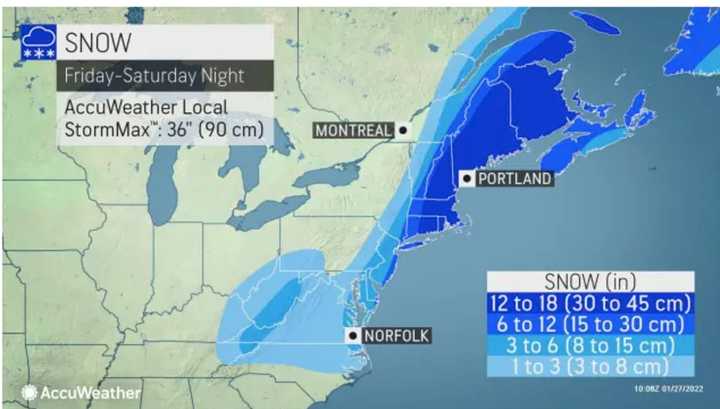
According to AccuWeather.com, areas farthest east (shown in dark blue in the second image above), could see between 12 and 18 inches of snowfall. Much of the region should see between 6 and 12 inches (shown in blue), with areas farther west seeing anywhere between 1 and 6 inches (lighter blue).
Thursday will be sunny with a high temperature in the mid to upper 20s, according to the National Weather Service.
Friday will be cloudy with a high temperature in the low 30s with a chance of light snow in the afternoon.
Current projections have the Nor'easter arriving shortly after midnight Saturday.
Saturday's high temperature will struggle to reach 20 degrees during the height of the storm.
Skies will clear on Sunday, Jan. 30 after the storm, with the high temperature in the mid 20s.
More certainty surrounding the track and strength of the No'easter is expected by Friday morning.
Check back to Daily Voice for updates.
Click here to follow Daily Voice Vernon-Rockville and receive free news updates.

