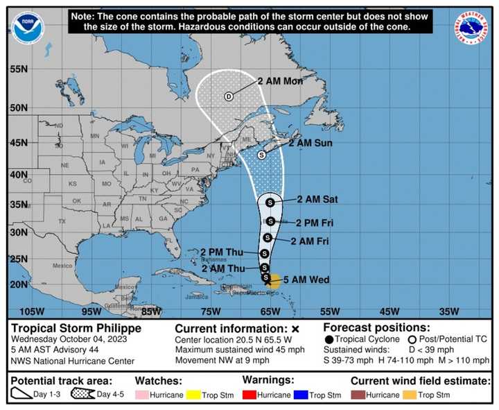
As of Wednesday morning, Oct. 4, the center of Tropical Storm Philippe is about 110 miles north-northwest of the Virginia Islands.
The storm is packed with 45 mph winds with higher gusts. Tropical-storm-force winds extend outward up to 150 miles from the center.
It's moving toward the northwest at around 9 miles per hour.
A turn toward the north-northwest is forecast later Monday, followed by a faster motion toward the north on Thursday, Oct. 5, and Friday, Oct. 7, according to the National Hurricane Center.
On the forecast track, the center of Philippe will continue to move away from Puerto Rico and the Virgin Islands on Wednesday. Philippe will then approach Bermuda on Thursday night and Friday.
Widespread rainfall of 4 to 8 inches is expected in the Virgin Islands with locally higher amounts as high as 12 inches.
Swells generated by Philippe will affect portions of the Atlantic coasts of the northern Leeward Islands, the Virgin Islands, and Puerto Rico for another couple of days. Swells are expected to reach Bermuda by late Thursday. These conditions are likely to cause life-threatening surf and rip currents. Please consult products from your local weather office.
For the storm's projected path through Monday, Oct. 9, see the image above.
The have now been 17 named storms of the 2023 season.
In early August, the National Oceanic and Atmospheric Administration increased its prediction for named storms this year from 12 to 17 to 14 to 21.
Sean is up next on the 2023 list of Atlantic storm names.
For more on Philippe from the National Hurricane Center, click here.
The hurricane season began Thursday, June 1 and ends on Thursday, Nov 30.
Check back to Daily Voice for updates.
Click here to follow Daily Voice Vernon-Rockville and receive free news updates.
