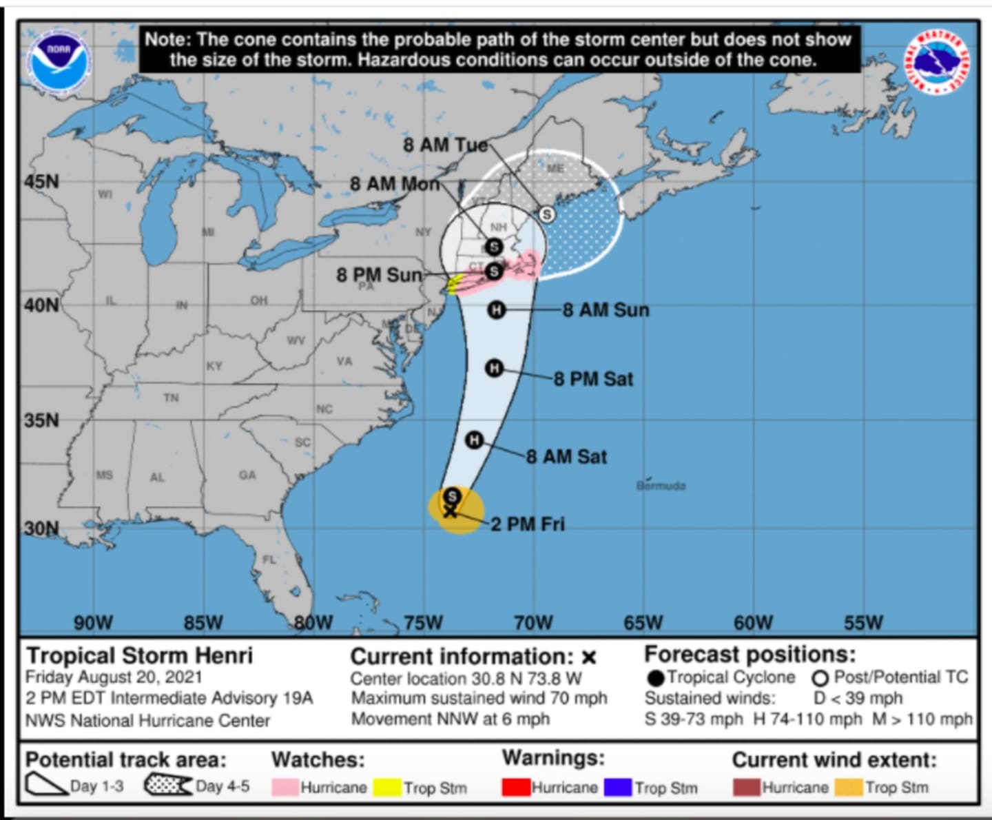


The latest models were released Friday afternoon, Aug. 20 by the National Weather Service NOAA National Hurricane Center.
If it strengthens to hurricane status as expected, Henri could be the first hurricane to make landfall in New England since Bob in 1991.
A Hurricane Watch has now been issued for portions of Long Island, Connecticut, and southeastern Massachusetts. Additional warnings and watches may be required later, the NOAA National Weather Service Hurricane Center said on Friday.
As of around 2 p.m. Friday, Henri (pronounced ON-ree) is located over the Atlantic Ocean about 320 miles south-southeast of Cape Hatteras, North Carolina, about 720 miles (1160 km) south of Montauk Point on Long Island.
Henri is moving toward the west-northwest near 6 mph. A turn toward the north is expected by Friday, and Henri is forecast to accelerate in that direction through early Sunday, Aug. 22. On the forecast track, Henri is expected to make landfall in southern New England by late Sunday.
Maximum sustained winds are near 70 mph with higher gusts.
Henri may produce rainfall amounts of 2 to 5 inches over eastern Long Island and southern New England Sunday into Monday, Aug. 23, with isolated maximum totals near 8 inches, the National Weather Service NOAA National Hurricane Center said Friday fternoon.
Heavy rainfall from Henri will result in flash, urban, and small stream flooding, along with the potential for widespread minor and isolated moderate river flooding.
A Hurricane Watch is in effect for:
- South Shore of Long Island from Fire Island Inlet to Montauk
- North Shore of Long Island from Port Jefferson Harbor to Montauk
- New Haven, Connecticut to Sagamore Beach Massachusetts
- Nantucket, Martha's Vineyard, and Block Island
A Tropical Storm Watch is in effect for:
- Southern Westchester
- West of Fire Island Inlet to East Rockaway Inlet, New York
- West of Port Jefferson Harbor, New York
- Coastal Fairfield County
Mapping Henri:
- For a look at Henri's current projected track, released Friday afternoon, see the first image above.
- Click on the second image above to see the latest predicted track and timing of Tropical-Storm-Force winds from Henri.
- Click on the third image above for a look at areas at risk for flash flooding (in yellow, and green), with areas in yellow at the highest risk.
- Click on the fourth image above for a look at areas (in red) where storm surge is expected.
- Click on the fifth image above for a look at projected rainfall totals from Henri.
This continues to be a developing story. Check back to Daily Voice for updates.
Click here to follow Daily Voice Brookfield and receive free news updates.